
Country United States | Time zone EST (UTC-5) | |
 | ||
State - District of Columbia
- Maryland
- Virginia
- Pennsylvania
- West Virginia Principal cities Washington, D.C.
Arlington, VA
Alexandria, VA
Baltimore, MD,
Annapolis, MD
Bethesda, MD
Columbia, MD
Easton, MD
Falls Church, VA
Frederick, MD
Fredericksburg, VA
Gaithersburg, MD
Hagerstown, MD
Lexington Park, MD
Martinsburg, WV
Rockville, MD
Reston, VA
Silver Spring, MD
Towson, MD
Waynesboro, PA
Winchester, VA | ||
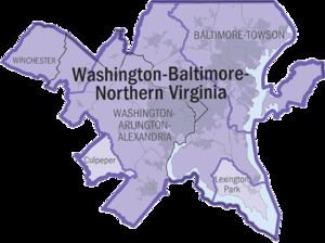
The Baltimore–Washington Metropolitan Area is a combined statistical area consisting of the overlapping labor market region of the cities of Washington, D.C. and Baltimore, Maryland. The region includes Central Maryland, Northern Virginia, three counties in the Eastern Panhandle of West Virginia, and one county in South Central Pennsylvania. It is the most educated, highest-income, and fourth largest combined statistical area in the United States.
Contents
- Components of the metropolitan area
- Metropolitan Washington Council of Governments
- Baltimore Metropolitan Council
- List of principal cities
- Baltimore area
- Washington area
- Biotechnology
- Defense contracting
- Notable company headquarters in the region
- Maryland
- Washington DC
- Northern Virginia
- Major airports
- Rail transit systems
- Major highways
- References
Officially, the area is designated by the Office of Management and Budget (OMB) as the Washington-Baltimore-Arlington, DC-MD-VA-WV-PA Combined Statistical Area. It is composed primarily of two major metropolitan statistical areas, the Washington–Arlington–Alexandria, DC–VA–MD–WV MSA and the Baltimore-Columbia-Towson, MD MSA. In addition, six other smaller urban areas not contiguous to the main urban area but having strong commuting ties with the main area are also included in the metropolitan area. These are: the Hagerstown-Martinsburg, MD-WV MSA, the Chambersburg-Waynesboro, PA MSA, the Winchester, VA–WV MSA, the California-Lexington Park, MD MSA, the Easton, MD micropolitan statistical area (µSA), and the Cambridge, MD µSA.
Some counties such as Caroline and King George County, Virginia are not officially designated by the OMB as members of this metropolitan area, but still consider themselves members anyway. This is mostly due to their proximity to the area, the size of their commuter population, and by the influence of local broadcasting stations. The population of the entire Washington-Baltimore Combined Statistical Area as of the Census Bureau's 2012 Population Estimates is 9,331,587. The most populous city is Washington, DC, with a population of 681,170. The most populous county is Fairfax County, Virginia, with a population exceeding 1.1 million.
Components of the metropolitan area
The counties and independent cities and their groupings that comprise the metropolitan area are listed below with their 2012 population estimates. Central counties/cities (designated as such by OMB) for each MSA are shown in italics.
Metropolitan Washington Council of Governments
Founded in 1957, the Metropolitan Washington Council of Governments (MWCOG) is a regional organization of 23 Washington-area local governments, as well as area members of the Maryland and Virginia state legislatures, the U.S. Senate, and the U.S. House of Representatives. MWCOG provides a forum for discussion and the development of regional responses to issues regarding the environment, transportation, public safety, homeland security, affordable housing, community planning, and economic development.
The National Capital Region Transportation Planning Board, a component of MWCOG, is the federally designated Metropolitan Planning Organization for the metropolitan Washington area.
Baltimore Metropolitan Council
The Baltimore Metropolitan Council is the equivalent organization for the Baltimore portion of the combined Baltimore–Washington metropolitan area. The BMC, which was created in 1992 as the successor to the Regional Planning Council and Baltimore Regional Council of Governments, consists of the Baltimore region's elected executives, representing Baltimore City and Anne Arundel, Baltimore, Carroll, Harford and Howard counties.
The Baltimore Regional Transportation Board is the federally recognized Metropolitan Planning Organization for transportation planning in the Baltimore region.
List of principal cities
See List of cities in the Baltimore–Washington metropolitan area for a full list.
Baltimore area
Washington area
Biotechnology
Not limited to its proximity to the National Institutes of Health, Maryland's Washington suburbs are a major center for biotechnology. Prominent local biotechnology companies include MedImmune, United Therapeutics, The Institute for Genomic Research, Human Genome Sciences and the Howard Hughes Medical Institute.
Defense contracting
Many defense contractors are based in Northern Virginia and Montgomery County, Maryland to be close to the Pentagon in Arlington. Local defense contractors include Lockheed Martin, the largest, as well as Northrop Grumman, General Dynamics, BAE Systems Inc., Computer Sciences Corporation (CSC), Booz Allen Hamilton, Leidos, Science Applications International Corporation (SAIC), and Orbital Sciences Corporation.
Notable company headquarters in the region
Numbers denote Fortune 500 ranking.
Maryland
Baltimore area:
Washington area:
Washington, D.C.
Northern Virginia
Major airports
Rail transit systems
Major highways
Interstates
U.S. Routes
State Routes