
Country Norway District Ofoten Area rank 118 in Norway Population 2,616 (2012) Official language form Bokmål | County Nordland Administrative centre Ballangen Demonym(s) Ballangsværing Local time Wednesday 1:38 AM | |
 | ||
Weather -3°C, Wind E at 19 km/h, 72% Humidity Area 930.8 km² (846.8 km² Land / 84 km² Water) | ||
Ballangen (Northern Sami: Bálák) is a municipality in Nordland county, Norway. It is part of the traditional district of Ofoten. The administrative centre of the municipality is the village of Ballangen. Other villages include Bjørkåsen, Kjeldebotn, Kobbvika, and Skarstad.
Contents
- Map of 8540 Ballangen Norway
- General information
- Coat of arms
- Name
- Churches
- History
- Government
- Municipal council
- Geography
- Notable residents
- Sister cities
- References
Map of 8540 Ballangen, Norway
The municipality borders Narvik to the east and Tysfjord to the south, and has a short border with Sweden to the southeast. Ballangen is situated on the southern shore of Ofotfjorden. Ballangen also includes the long and narrow Efjorden, just south of the much larger Ofotfjorden. Its immediate surroundings are dominated by fjords, mountains, and forests. Ballangen relies on the neighbouring Narvik as its economic base.
The village of Ballangen lies along the southern shore of the Ofotfjorden along the European route E06 highway. The highway crosses the Efjord Bridges on its way to Ballangen and then on again to the town of Narvik. The 0.93-square-kilometre (230-acre) village of Ballangen has a population (2013) of 827. The population density is 889 inhabitants per square kilometre (2,300/sq mi).
General information
The municipality of Ballangen was established on 1 July 1925 when it was separated from the large municipality of Evenes. The new municipality encompassed all of Evenes located south of the Ofotfjorden. Initially, Ballangen had 3,270 residents. On 1 January 1962, the southern part of Lødingen (the island of Barøya and the area surrounding the Efjorden; population: 433) was transferred from to Ballangen. The borders have not changed since.
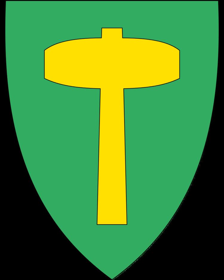
Coat-of-arms
The coat-of-arms is from modern times; they were granted on 18 July 1980. The arms show a gold hammer on a green background. It was chosen as a symbol to represent the mining in the municipality. There used to be copper mines in the municipality. The green background symbolizes agriculture.
Name
The Old Norse form of the name was Bagangr. The meaning of the first element is not known and the last element is angr which means "fjord".
Churches
The Church of Norway has one parish (sokn) within the municipality of Ballangen. It is part of the Ofoten deanery in the Diocese of Sør-Hålogaland.
History
The first person living in Ballangen was Lodve Lange (Lodve the long), who is mentioned in Heimskringla as being one of King Olav Tryggvason's most trusted warriors, and being placed near the king in the famous ship Ormen Lange (long serpent). Lodve probably participated in the Battle of Svolder in the year 1000, and might have been killed there. He lived at Saltvik, which is near the fjord, east of today's village of Ballangen.
There is a long history of mining in Ballangen, starting from the 17th century. Over the years as many as 36 mines have been operated in Ballangen, including minerals like copper, nickel and iron, zinc, manganese, and lead, but the most serious mining started in 1911 with Bjørkåsen Gruver mining mostly pyrite. Mining for nickel and olivine continued until 2002. There is also a dolomite quarry in Ballangen. Ballangen is the main agricultural municipality in the Ofoten region.
Government
All municipalities in Norway, including Ballangen, are responsible for primary education (through 10th grade), outpatient health services, senior citizen services, unemployment and other social services, zoning, economic development, and municipal roads. The municipality is governed by a municipal council of elected representatives, which in turn elect a mayor.
Municipal council
The municipal council (Kommunestyre) of Ballangen is made up of 17 representatives that are elected to every four years. Currently, the party breakdown is as follows:
Geography
The Efjorden area is dominated by large slopes of bare rock with a narrow green area of vegetation near the fjord. The obelisk-like mountain, Stetind, nearby is dominated by the same, dark blue-grey rock, which contrasts with the clear water in the fjord where the sand banks can be seen just below the surface. Climbers and hikers are often tempted to test their skills on the rocky slopes. The large Frostisen glacier is located in the southeastern part of the municipality.
In the east, Ballangen borders on lake Siiddašjávri which it shares with Sweden. Siiddašjávri is the 14th largest lake which lies in or partially in Norway. Other lakes in the municipality include Børsvatnet, Geitvatnet, Hjertvatnet, Kjelvatnet, Langvatnet, Melkevatnet, Røvatnet, Søre Bukkevatnet, and Storvatnet.
The island of Barøya sits near the entrances to the Ofotfjorden and Efjorden. The Barøy Lighthouse sits on the northern edge of the island.