
Country Canada RCM Minganie Postal code(s) G0G 1B0 Area 525.4 km² Local time Tuesday 9:39 AM Named for Johan Beetz | Region Côte-Nord Constituted 1 January 1966 Elevation 10 m Population 81 (2011) Province Québec | |
 | ||
Time zone Within the AST legislated time zone boundary but observes EST (UTC-5) Weather -10°C, Wind W at 19 km/h, 60% Humidity | ||
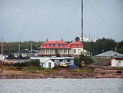
Baie-Johan-Beetz is a municipality and village in the Côte-Nord region of the province of Quebec in Canada, located some 60 kilometres (37 mi) east of Havre-Saint-Pierre. It has the lowest population of all incorporated places in the Côte-Nord region.
Contents
Map of Baie-Johan-Beetz, QC, Canada
History
The first settlers came from the Magdalen Islands, and one family came from Berthier-sur-Mer. The place was originally identified as "Piastre Bay", from the Innu expression piashite-pets, meaning "there where the water passes over/on top", or possibly originating from the word piashtibé, meaning "dry bay" or "where the water rises", which is a reference to the local bay that during low tide runs dry.
But the bay's name was spelled in a variety of ways, including Piashti Bay, Pillage Bay, Baie-de-Pillage, Piastibe, Piashte Bay, and Piestebé. Perhaps for this reason, its residents expressed a desire to change the village's name to Baie-Johan-Beetz in 1910. Johan Beetz (1874-1949) was a Belgian naturalist, who lived in the Bay from 1897 to 1922. He had moved there to breed fur animals, particularly foxes, and built a luxurious manor that residents today call le château (the castle). The bay was renamed in 1914, but the name was not officially adopted until 1965 when the place was incorporated.
In 1996, Highway 138 was extended to Baie-Johan-Beetz, linking it to the municipality of Havre-Saint-Pierre and thereby breaking its isolation.
Transports
The city is served by the Baie-Johan-Beetz Seaplane Base (SPB) (IATA: YBJ).