
Climate BSk Area code 02920 | ||
 | ||
Bahía Creek is a beach resort village at 41.0836° S, 63.9317° W, and municipality in the Adolfo Alsina Department of the Río Negro Province in Argentina.
Contents
Map of Bah%C3%ADa Creek, R%C3%ADo Negro, Argentina
Location
Bahía Creek is located on the northern coast, at the beginning of the San Matías Gulf. It is located 135 km from Viedma and 100 km from Balneario El Cóndor, accessed by the Provincial Route 1 (RP 1) that borders the Argentine Sea, and RP 51. By RP 1 from Viedma, there are 60 km of asphalt until the Lobería and then 75 km of gravel road.
Geography
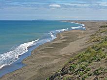
Bahía Creek is an area of low cliffs, with dunes and wide sandy beaches. It is a place for summer and weekend homes. There is also a Fishermen's Club. Las Conchillas beach lies along the coast.
Nature
The Southern Right Whales are the biggest feature in the area. Swim-with-whales tours are available in San Matías Gulf, being the only location in the world that swimming with this species is legally permitted. Dolphins can also be seen from shores.