
Postal codes 08645 Area 23.42 km² Population 3,874 (31 Dec 2008) Dialling code 037437 | Time zone CET/CEST (UTC+1/+2) Dialling codes 037437 Local time Tuesday 12:15 AM Postal code 08645 | |
 | ||
Weather 7°C, Wind S at 21 km/h, 60% Humidity | ||
Bad Elster ( [ˌbaːt ˈɛlstɐ]) is a spa town in the Vogtlandkreis district, in the Free State of Saxony, Germany. It lies on the border of Bavaria and the Czech Republic in the Elster gebirge hills. It is situated on the river White Elster, and is protected from extremes of temperature by the surrounding wooded hills. It is 25 km southeast of Plauen, and 25 km northwest of Cheb. The B 92 runs close by.
Contents
- Map of Bad Elster Germany
- Elster before 1900
- Bad Elster in the 19th and 20th century
- Places
- Demography
- Business
- Town Council
- Coat of Arms
- Attractions
- Twin town
- Sons and daughters of the town
- Those associated with the site
- References
Map of Bad Elster, Germany
It is part of the Freunde im Herzen Europas microregion.
Elster before 1900
Two kilometers north west of the town centre lies the remains of a twelfth-century walled village, known today as the "Alte Schloss" or "Old Castle". This was first documented in 1324.
1412 a manor was sold to the von Zedtwitz family, who held it until 1800.
1533 the Reformation reaches Adorf and its daughter church in Elster, and the first Protestant pastor was installed in 1540.
The healing properties of the waters from the spring now known as the Moritzquelle were recognised well before, Georg Leisner, physician to the Duke Moritz von Sachsen-Zeitz, wrote in 1669 that inhabitants of both Adorf and Elster come to the spring to take the waters, and he had successfully used them on many different patients.
One famous visitor was Johann Wolfgang von Goethe, who came in 1795. He mentions the spring at Elster in his work Hermann and Dorothea.
(Bad) Elster in the 19th and 20th century
Elster became an independent parish in 1851. In 1892 the old St. Peter und Paul church was demolished and replaced with the Revival Gothic, St. Trinitatiskirche.
Elster was promoted to be the "Königlich-Sächsischen Staatsbad", official royal spa of Saxony in 1848. With that the visitor numbers rose: 1848: 129; 1850: 378, 1860: 1.750, 1870: 2450, 1890: 5870, 1900: 8900, 1990: 15.600.
Elster prepended the Bad meaning "spa" in 1875, Bad Elster became its official name in 1935. In 1880, "Bademuseum Bad Elster" opened, it was the first museum in the town and in Vogtland, it was short lived. A new museum opened in 1993.
Places
Places within Bad Elster include Sohl and Mühlhausen.
Demography
Growth of Population (from 1964 on, as of December 31st):
Business
The main industries are tourism and health. There are seven clinics specialising in recuperation. In 2005 there were 35 establishments offering accommodation with 2400 beds, and receiving 540,000 bednights.
The town lies near the B 92. There are two open border crossings into the Czech Republic; open for pedestrians and bicycles but not cars, though post Schengen even the barrier has been removed. The station is 2.5 km from the town centre at Mühlhausen on the Plauen Eger line where there is a two hourly service.
Town Council
The elections in May 2014 showed the following results:
Coat of Arms
Field gold (or), with a naturalistic Magpie standing on three green hills (vert). From centre hill, a spring (argent) with water flowing to pool (argent).
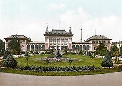
Attractions
The most important buildings in Bad Elster are from the last quarter of the 19th century.