
Population 109 (2001 Census) Civil parish Backford Local time Monday 9:01 PM | OS grid reference SJ398720 Sovereign state United Kingdom Dialling code 01244 | |
 | ||
Weather 2°C, Wind SW at 13 km/h, 89% Humidity | ||
Jones homes the harrington backford park chester
Backford is a village and civil parish in the unitary authority of Cheshire West and Chester and ceremonial county of Cheshire, England. It is situated between Chester and Ellesmere Port on the A41 trunk road, to the north of the Shropshire Union Canal. (Map) Backford Cross is located about 1.5 miles (2 km) north of Backford. According to the 2001 Census, it had a population of 109.
Contents
- Jones homes the harrington backford park chester
- Map of Backford Chester UK
- Reverse it the backford bomber jacket
- References
Map of Backford, Chester, UK
Formerly a township in the Wirral Hundred, it had a population of 138 in 1801, 155 in 1851, 141 in 1901 and 119 in 1951.
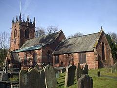
St Oswald's Church is in the centre of the village, as is Backford Hall, which previously operated as offices for Cheshire West and Chester Council.
Backford Hall Golf Club (now defunct) was in existence from the late 1930s until the early 1950s.