
Population 34,175 (2004) | City Homs | |
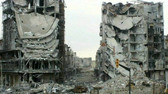 | ||
Syria amateur video explosions as warplanes bomb baba amr district of homs
Baba Amr (Arabic: بابا عمرو/ALA-LC: Bâba ʿAmr) is a city district (hayy) in southwestern Homs in central Syria. In 2004, it had a population of 34,175 (the hayy of Sultaniya which abuts Baba Amr to the south was also counted in this figure). Abutting Baba Amr and Sultaniya from the north and south respectively are the city districts of Inshaat and the village of Jobar. To the west are the villages of Aysun, Shalluh and al-Mazra'a and to the east is Homs' Palestinian refugee camp.
Contents
- Syria amateur video explosions as warplanes bomb baba amr district of homs
- Map of Baba Amr HomsE2808E Syria
- Syria un observers visit baba amr
- References
Map of Baba Amr, Homs%E2%80%8E, Syria
In the early 20th century, Baba Amr was a village in Orontes plain southwest of Homs. The modern district was formed largely as a result of Bedouin migration from the desert steppe east of Homs to the city's suburbs in the 1960s and 1970s. The Bedouin moved to the area due to land reforms by the Ba'athist government of President Hafez al-Assad which saw many semi-nomadic Bedouin settle in the suburbs of major cities. Most of Baba Amr's inhabitants self-identify as members of the Mawali and Bani Hassan tribal confederations. The inhabitants are predominantly Sunni Muslims.