
Highway system Brazilian Highway System | ||
 | ||
Length: 2,894.35 mi (4,658.00 km) Existed: 1957 (Curitiba - Florianópolis segment)
1950s (Florianópolis - Torres segment)
década de 1960/70 (Torres - Parnamirim segment)
1980s (Rodovia Rio-Santos)
1950s/1960s (Rio de Janeiro - Salvador segment)
1988(divided highway on the Curitiba - Florianópolis segment)
2009 (divided highway on the Florianópolis - Osório segment)
1958 (Salvador - Touros segment)
2002 (divided highway on the Salvador - Touros segment) – present North end: RN-023 in Touros, Rio Grande do Norte South end: São José do Norte, Rio Grande do Sul Major cities Rio de Janeiro, Natal, Serra, Campos dos Goytacazes | ||
For the diesel multiple unit that operated in the United Kingdom, see British Rail Class 101.
Contents
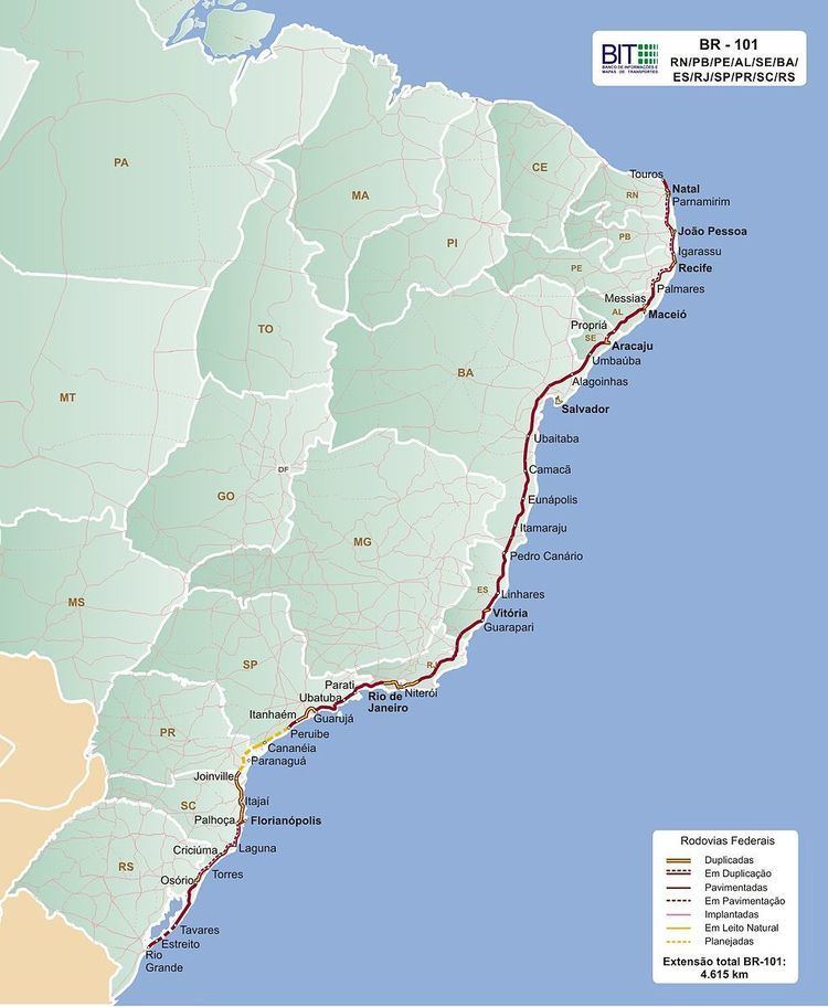
Map of BR-101, Brazil
For the electric locomotive currently operating in Germany, see DB Class 101.
The BR-101 (also called Translitorânea (transcoastal), officially named Rodovia Governador Mário Covas. and nicknamed Briói in some regions) is a longitudinal highway of Brazil. It is the longest in the country with a length of nearly 4,800 km (3,000 mi), and it is considered the second most important.
It crosses 12 Brazilian states: Rio Grande do Norte, Paraíba, Pernambuco, Alagoas, Sergipe, Bahia, Espírito Santo, Rio de Janeiro, São Paulo, Paraná, Santa Catarina and Rio Grande do Sul. It also connects more state capitals than any other "rodovia" (highway) in the country. In total, 12 capitals are directly connected by BR-101.
Its northern terminus is located in the city of Touros-RN and its southern terminus is located in São José do Norte-RS.
It follows virtually the entire east coast of Brazil from Rio Grande do Norte to Rio Grande do Sul. The highway has not been built between two stretches between Peruíbe (SP) and Iguape (SP), and between Cananéia (SP) and Garuva (SC).
It is a major Brazilian highway and part of the Pan-American Highway.
Between Curitiba and Garuva (SC), the highway was replaced by the BR 101 / BR 376 and was widened by the Paraná government, not by the federal government.
The northern section between Curitiba and the border with São Paulo was not built in order to preserve an area of the Atlantic Forest.
The Rio-Niterói Bridge is part of the BR-101.
Improvements
In 1973 the first stretch was widened between Rio de Janeiro-RJ and Cubatão-SP. In the 1980s the stretch between Cubatão-SP and Curitiba-PR was widened. In the 1990s the 312 km stretch between Curitiba-PR and Florianópolis-SC has been widened. The 404 km stretch between Natal-RN and Palmares-PE was also widened.
The 350 km stretch that connects Florianópolis to Porto Alegre–RS from Palhoça (SC) to Osorio (RS) is being widened.
The works on widening the road between Palmares-PE and Porto Real do Colégio-AL has already started. The work in a 10 km stretch in Joaquim Gomes is halted due to the lack of licenses to wide the road inside the area which belongs to the Uassu-Cocal Indian tribe.
One of the next sections to be widened soon is the stretch between Rio de Janeiro and Espírito Santo.