
Peak Diebische Ecke Parent range Calenberg Uplands | Elevation 375 m (1,230 ft) | |
 | ||
State Between Bad Eilsen and Bad Nenndorf; Schaumburg; Lower Saxony (Germany) Type of rock Limestone, sandstone, shale, stone coal Types of rock Limestone, Sandstone, Slate, Anthracite | ||
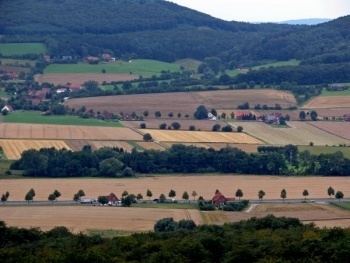
The Bückeberg (also the Bückeberge) is a small hill range, up to 375 metres high, in the Calenberg Uplands between the Harrl and the Deister in central Germany, and is often considered part of the Weser Uplands. It lies in the district of Schaumburg, and stretches for some 20 km (12 mi) from west to east from Bückeburg and the village of Bad Eilsen towards Bad Nenndorf.
Contents
- Map of Buckeberg 31655 Stadthagen Germany
- TopographyEdit
- GeologyEdit
- Hills in the BckebergEdit
- StreamsEdit
- Flora and faunaEdit
- Economic utilisationEdit
- Military useEdit
- Leisure activitiesEdit
- Forest restaurants in and around the BckebergEdit
- HistoryEdit
- EtymologyEdit
- MythsEdit
- References
Map of Buckeberg, 31655 Stadthagen, Germany
TopographyEdit
The ridge runs from southwest to northeast for about 20 kilometres at heights of 200 m to about 375 m. It only has a few summits, like the Bückeberg (or Diebische Ecke) (ca. 375 m), east of the track junction on the Eulenburg Way, and the Großer Karl (301.7 m) near Reinsdorf. Here its course swings north and ends with the foothills of Münchhausener Berg and Heisterberg near Beckedorf. The gentle northern dip slope descends into the North German Plain, whilst the steeper southern scarp slope drops into the Aue valley, through which the A 2 autobahn runs. The Heeßer Berge in the west is a nature reserve.
The ridge is cut through in two places: at Bad Eilsen near the western end, where the river Aue has cut a gap in the ridge, and at the Reinser Paß (pass) near the eastern end.
GeologyEdit
The crest of the Bückeberg consists of a hard, light sandstone, known as Obernkirchen sandstone, which is one of the best in Europe and, because of its transshipment through Bremen, is known internationally as Bremen Sandstone. The western Bückeberg contains clay and anthracite that used to be mined here. In the eastern section there are Jurassic limestones with halite (rock salt) deposits. It is here near Soldorf that the brine springs emerge which extend to the spa town of Bad Nenndorf, where they are used for bathing.
Hills in the BückebergEdit
The hills and high points of the Bückeberg include the following − sorted by height in metres (m) above sea level (Normalhöhennull or NHN):
StreamsEdit
Numerous streams drain the Bückeberg and feed the Aue (Bückeburger Aue) and the Rodenberger Aue. Several of them are only winterbournes.
Flora and faunaEdit
The Bückeberg is covered in mixed woods of beech and spruce, but there are also many other types of tree like the coast Douglas-fir, birch, maple and hornbeam. In addition there are many species of wild flower including the spring snowflake, mezereon, common broom and various ferns and fungi.
The Bückeberg is home to the roe deer, mouflon and wild boar. More rarely seen are the barn owl, common kestrel, red kite, pine marten and stone marten.
Economic utilisationEdit
In addition to forestry, quarrying plays an important role. The Obernkirchen sandstone of the Bückeberg has been used in many well-known buildings, such as Cologne Cathedral, the town halls in Bremen and Antwerp and the stock exchange in Bergen, Norway. Coal has also been mined in Bückeberg for centuries.
Military useEdit
On the Bückeberg near Obernkirchen at the northeastern end of the ridgeway is a former NATO anti-aircraft missile station. The terrain, which has grown wild since the withdrawal of Dutch soldiers, is surrounded by fencing and, today, is almost solely used for landing exercises by helicopters from the nearby School of Army Aviation in Bückeburg. Occasionally, tented exercises lasting several days by Training Group (Lehrgruppe) B take place on the site.
Leisure activitiesEdit
There are a number of scenic walking trails on the Bückeberg with views over the valleys, but also many gloomy forestry tracks without any signing. When walking it is advisable to take maps and the relevant information. On the Bückeberg near Obernkirchen there is the Youth Training Leisure Centre (Jugend-Bildung-Freizeit-Zentrum or JBF-Zentrum).
Forest restaurants in and around the BückebergEdit
HistoryEdit
EtymologyEdit
On several maps the hills are called the Bückeberge ("Bücke hills"). In the Lower Saxon dialect it is not unusual to treat such a name as singular (Wir gehen zum Bückeberge = "we are going to the Bückeberge"). In the Nazi era attempts were made to rename the Bückeberg in Schaumburg as the "Bückeburg Forest" or "Bückeberge", in order to distinguish it from the hills of the same name near Hagenohsen, where the Reich's harvest festival was celebrated. Occasionally the plural is found even before 1933 in old maps. On official maps the plural form was first used in 1961. The Lower Saxony State Survey Department (Landesvermessungsamt Niedersachsen or LGN) laid down in 2005 that the name Bückeberg would be used for the ridge in its fullest extent, so that now the traditional name, used for centuries, has now been adopted on the maps. The Bückeberg lies in the old Germanic district (Gau) of Bukkigau (Bukki = Beech), and therefore means the "hill in the beeches" (Berg im Bukki) or the "Beech Hill" (Buchen-Berg).
MythsEdit
Old folk tales tell of the so-called Böxenwolf, a type of werewolf, which would ambush lone travellers walking through the Bückeberg, or even between the surrounding villages, at night. It would jump on their back and then jump off again after a while.