
Post Code 371 Population 266 (2014) | Constituency Northwest Constituency Time zone GMT (UTC+0) Local time Thursday 6:43 PM Municipality Dalabyggð | |
 | ||
Weather -3°C, Wind E at 6 km/h, 67% Humidity | ||
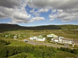
Búðardalur is a village situated on the Hvammsfjörður in the north-west of Iceland.
Contents
Map of B%C3%BA%C3%B0ardalur, Iceland
The village also lies at the north-eastern end of the Snæfellsnes peninsula and is part of the municipality of Dalabyggð. Búðardalur had about 270 inhabitants in 2014 and is a service center for the area, including the regional tourist information centre. In the traditional system of counties of Iceland that existed until the late 1980s, it was part of Dalasýsla, a name that is still used for the region.
Overview
Búðardalur contains a supermarket and a petrol station, hair salons, a pub/restaurant, a coffee shop, a health-care centre, an off-licence, a garage and a craft shop; the information centre is in the same building as a cafe and a folk museum.
The village has a long history, dating from the time of the first settlements in Iceland. The name means "Camp Valley", or more directly "dale of booths"; it is where settlers had temporary camps when coming to the area. In 1899, Búðardalur was officially granted the right of commerce. An old house from this time still exists.
At a short distance from the village is Eiríksstaðir, the homestead of Erik the Red, who discovered Greenland and whose son Leif Erikson, born at Eiríksstaðir, discovered America ahead of Columbus.