
Surface area 12.99 km (5.02 sq mi) Area 12.99 km² Surface elevation 125 m Inflow source Spree | Max. depth 50 m (160 ft) Shore length 20.6 km Outflow location Schwarzer Schöps Cities Klitten | |
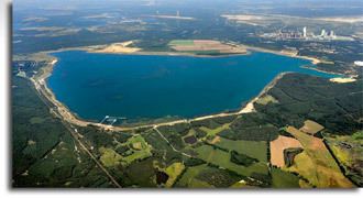 | ||
Primary inflows Water volume 174,000,000 m (6.1×10 cu ft) | ||
Bärwalder See is a lake in Boxberg municipality, Görlitz district, Saxony, Germany. At an elevation of 125 m, its surface area is 12.99 km².
Map of B%C3%A4rwalder See, 02943, Germany
References
Bärwalder See Wikipedia(Text) CC BY-SA