
Country Greece Postal code 402 00 Vehicle registration PIx-xxxx Municipality Elassona Municipal unit Sarantaporo | Time zone EET (UTC+2) Area code(s) +30-2493-xxx-xxx Elevation 520 m Administrative region Thessaly Regional unit Larissa | |
 | ||
La hora del t le los azoros parte 4
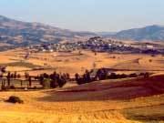
Azoros (Greek: Άζωρος, ['azoɾos]) is a village and a community of the Elassona municipality. Before the 2011 local government reform it was a part of the municipality of Sarantaporo, of which it was a municipal district. The 2011 census recorded 333 inhabitants in the village. The community of Azoros covers an area of 20.308 km2.
Contents
Map of Azoros 402 00, Greece
Economy
The population of Azoros is occupied in animal husbandry and agriculture.
Population
According to the 2011 census, the population of the settlement of Azoros was 333 people, a decrease of almost 33% compared with the population of the previous census of 2001.
References
Azoros Wikipedia(Text) CC BY-SA