
Intercommunality Haute Vallée d'Aure Area 26.63 km² | Region Occitanie Time zone CET (UTC+1) Population 159 (2006) | |
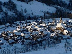 | ||
Azet is a French commune in the Hautes-Pyrénées department in the Occitanie region of south-western France.
Contents
- Map of 65170 Azet France
- Geography
- Climate
- Toponymy
- History
- Administration
- Demography
- Civil heritage
- Religious heritage
- References
Map of 65170 Azet, France
The inhabitants of the commune are known as Azetois or Azetoises.
Geography
Azet is located some 55 km south by south-east of Tarbes and 20 km west of Bagnères-de-Luchon. Access to the commune is by road D225 from Estensan in the west to the village. The public square of the village is 1,172 metres above sea level at the intersection of the Aure and Louron valleys with the Col de Val Louron-Azet to the south-east. The commune is very rugged and inaccessible with extensive forests in the south.
The Ruisseau de Lustau flows north from the Lustou Lake in the south of the commune, gathering many tributaries including the Ruisseau de Sarrouyes which flows from lakes in the south-east of the commune, and becoming the Mousquere before passing the village and continuing north to join the Neste d'Aure north of Vielle-Aure.
Climate
Azet has a mountain climate with high temperatures in summer.
Toponymy
The probable etymology of the name is Adet, adou, ados, âne, asou, then Azet meaning a place marking the end of the terrain which could only be crossed by donkey or horse.
History
There is little evidence to trace the origin of the village except the church, which dates from the fourth quarter of the 12th century In 1887 the village had two primary schools. Village resources were mainly pastoralism with livestock farming of sheep, cows, horses, and donkeys as well as crops such as wheat, rye, meslin, barley, buckwheat, beans, peas, potatoes, turnips, flax sprouts, and hay.
From the 1880s the population decreased due to the waves of typhoid fever during 1886-1887 and the rural exodus of young people.
Administration
List of Successive Mayors
(Not all data is known)
Demography
In 2010 the commune had 161 inhabitants. The evolution of the number of inhabitants is known from the population censuses conducted in the commune since 1793. From the 21st century, a census of communes with fewer than 10,000 inhabitants is held every five years, unlike larger communes that have a sample survey every year.
Sources : Ldh/EHESS/Cassini until 1962, INSEE database from 1968 (population without double counting and municipal population from 2006)
Civil heritage
The commune has a number of sites that are registered as historical monuments:
Religious heritage
The Church of Our Lady of the Assumption (12th century) is registered as an historical monument. The Church contains a very large number of items that are registered as historical objects. For a complete list together with links to descriptions (in French) and some photos click here.