
Area 27.65 km² | Population (2010) 987 | |
 | ||
Ayherre (Basque: Aiherre) is a French commune in the Pyrénées-Atlantiques department in the Nouvelle-Aquitaine region of south-western France.
Contents
- Map of 64240 Ayherre France
- Geography
- Toponymy
- History
- Administration
- Inter communality
- Demography
- Economy
- Civil heritage
- Religious heritage
- Education
- Notable people linked to the commune
- References
Map of 64240 Ayherre, France
The inhabitants of the commune are known as Aihertars.
Geography
Ayherre is located in the Arberoue Valley in the former province of Lower Navarre some 23 km east by south-east of Bayonne and immediately east of Hasparren. Access to the commune is by the D10 road from Hasparren which passes through the west of the commune and continues north to La Bastide-Clairence. The D251 branches east off the D10 in the commune and goes to the village then continues east to Isturits. The D314 goes south-west from the village to Bonloc. The D14 from Bonloc to Saint-Esteben passes through the south of the commune. The commune is mainly farmland with scattered forests.
The commune is located in the drainage basin of the Adour with a dense network of streams covering the commune, mostly flowing north-westwards, and including the Joyeuse, which forms part of the western border of the commune. The Arbéroue rises in the south of the commune and flows north gathering many tributaries before joining the Lihoury to the north.
Toponymy
The commune name in basque is Aiherra. According to Jean-Baptiste Orpustan, the name comes from the basque ailherr ("incline"), giving the meaning "place on a slope".
The following table details the origins of the commune name and other names in the commune.
Sources:
Origins:
History
On 18 March 1450, Labourd returned to the French crown after the signing of a peace treaty at the Château of Belzunce in Ayherre which marked the end of English influence in the region. On that the representatives of Labourd made their submission and, upon payment of 2,000 gold écus secured by the retention of 10 hostages, retained their privileges.
Administration
List of successive mayors
(Not all data is known)
Inter-communality
The commune is part of six inter-communal structures:
Demography
The declaration of rights in 1749 counted 162 fires in Ayherre (130 third estate, one priest, two members of the nobility (Arcangues and Belsunce) and 29 non-owners).
In 2010 the commune had 987 inhabitants. The evolution of the number of inhabitants is known from the population censuses conducted in the commune since 1793. From the 21st century, a census of communes with fewer than 10,000 inhabitants is held every five years, unlike larger communes that have a sample survey every year.
Sources : Ldh/EHESS/Cassini until 1962, INSEE database from 1968 (population without double counting and municipal population from 2006)
Economy
Economic activity in the commune is mainly agricultural. The commune is part of the Appellation d'origine contrôlée (AOC) zone of Ossau-iraty.
The Lauak company (aeronautical and aerospace industry) is located in the industrial zone of Ayherre.
The Uhagun Mill on the Aran dates to the 19th century and has been converted into a hydro-electric plant.
Civil heritage
The commune has three sites that are registered as historical monuments:
Religious heritage
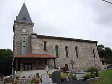
The Parish Church of Saint Pierre (17th century) is registered as an historical monument.
Education
The commune has two primary schools: one in the town and one private school of the Immaculate Conception.