
Department Bas-Rhin Population (2010) 728 Area 183 ha | Time zone CET (UTC+1) Local time Friday 2:59 PM | |
 | ||
Weather 12°C, Wind SE at 8 km/h, 52% Humidity | ||
Avolsheim is a French commune in the Bas-Rhin department in the Grand Est region of north-eastern France.
Contents
- Map of 67120 Avolsheim France
- Geography
- Toponymy
- Until the Revolution
- Since the French Revolution
- Administration
- Demography
- Civil heritage
- Religious heritage
- References
Map of 67120 Avolsheim, France
The inhabitants of the commune are known as Avolsheimois or Avolsheimoises.
The commune has been awarded one flower by the National Council of Towns and Villages in Bloom in the Competition of cities and villages in Bloom.
Geography
Avolsheim is located some 22 km west by south-west of Strasbourg and 18 km north of Obernai. Access to the commune is by the D422 from Odratzheim in the north which passes through the centre of the commune and the town and continues south to Molsheim. The D127 goes east from the town to Dachstein. Apart from the significant sized urban area the commune is mixed forest and farmland.
The Bruche river flows north through the east of the commune and abruptly turns right near the northern border of the commune before continuing east to join a branch of the Rhine at Strasbourg. The Mossig river flows from the north-west forming the northern border of the commune before joining the Bruche.
Toponymy
The first written record of the name of a village in the current commune dates from the year 788 and is called Hunzolfesheim. It was found in 1051 spelled Avelsheim then Afelsheim in 1350 with a dialectal form Âfelse. In 1496 it was written Afeltzheim and in 1589 Avelssheim again but with two "s". Since then, the village has had its present name and its spelling has not changed.
The prefix offe (offen in German = "open") was the origin of the name Avolsheim and therefore means "Open Town". It is possible that this name was given to the village since it was devoid of walls, which in the Middle Ages was relatively rare.
There is an old local saying in dialect: Es steht offe wie Âfelse ("It is as open as Avolsheim") suggesting that at one time the steeple at Avolsheim, which remained so long in ruins so was "open to the sky", that this could have been the origin of its name. This argument, with the previous one, are confirmed by the popular phrase, Fescht wie Landau un Offe wie Âfelse meaning "A Fort (or fortified) like Landau or open like Avolsheim".
Until the Revolution
Avolsheim is located on the Gallo-Roman road linking Molsheim to Saverne. Many objects dating from this period were excavated in 1930.
In the 10th century the area had two distinct hamlets: Avelsheim one hand, corresponding roughly to the current village, and Tumpfieter, Dompieter, or Domphietenheim, a village consisting of a group of a few farms and a mill located at a church called the Dompeter.
The last mention of this hamlet was in the 16th century. It probably died as a village by the end of the same century. For some historians doubt remains: it may have disappeared in the 17th century, its destruction following the Siege of Dachstein by the armies of Turenne.
According to the papal bull of Leo IX in 1051 Avolsheim, including the Mont Sainte-Odile Abbey, was part of the possessions of the bishopric of Strasbourg.
Avolsheim was put in vassalage to the Counts of Ostoffen, then to von Murnhart in 1384, and finally remained with von Beger until 1521. From 1534 until the Revolution, the area was a fief of the dignitaries of the diocese.
Since the French Revolution
The village has been linked to the sub-prefecture of Molsheim since the Revolution.
Avolsheim was once on the Sélestat to Saverne railway line before the section from Molsheim to Saverne was removed in 1967 and replaced with a bicycle path.
Administration
List of Successive Mayors
(Not all data is known)
Demography
In 2010 the commune had 728 inhabitants. The evolution of the number of inhabitants is known from the population censuses conducted in the commune since 1793. From the 21st century, a census of communes with fewer than 10,000 inhabitants is held every five years, unlike larger communes that have a sample survey every year.
Sources : Ldh/EHESS/Cassini until 1962, INSEE database from 1968 (population without double counting and municipal population from 2006)
Civil heritage
The commune has many buildings that are registered as historical monuments:
The Avolsheim Dam was built in 1682 on the Bruche Canal that was built by Vauban. This canal was used to transport blocks of sandstone to Strasbourg from quarries at Soultz-les-Bains and Wolxheim which were necessary for the construction of the Citadel of Strasbourg. This dam enabled the keeping of the water level high enough to supply the canal located a little further down.
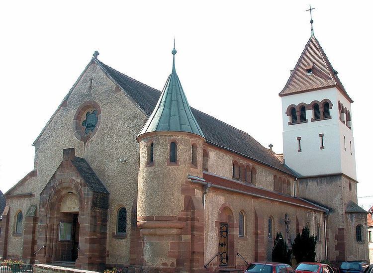
Religious heritage
The commune has two religious buildings that are registered as historical monuments: