
Intercommunality Pays rethélois Area 20.99 km² | Canton Château-Porcien Population (2010) 328 Local time Friday 10:16 AM | |
 | ||
Weather 7°C, Wind E at 14 km/h, 69% Humidity | ||
Avançon is a French commune in the Ardennes département in the Grand Est region of northern France.
Contents
- Map of 08300 AvanC3A7on France
- Geography
- Administration
- Demography
- Religious heritage
- Notable people linked to the commune
- References
Map of 08300 Avan%C3%A7on, France
The inhabitants of the commune are known as Avançonnais or Avançonnaises.
Geography
Avançon is located some 10 km south-west of Rethel and 11 km east of Asfeld. Access to the commune is by the D18 road from Acy-Romance in the north-east which passes through the commune to the village near the centre then continues west to Blanzy-la-Salonnaise. The D26 road goes from the village north to Taizy. The D150 goes south-west from the village to Saint-Loup-en-Champagne. The commune is entirely farmland.
Administration
List of Successive Mayors
(Not all data is known)
Demography
In 2010 the commune had 328 inhabitants. The evolution of the number of inhabitants is known from the population censuses conducted in the commune since 1793. From the 21st century, a census of communes with fewer than 10,000 inhabitants is held every five years, unlike larger communes that have a sample survey every year.
Sources : Ldh/EHESS/Cassini until 1962, INSEE database from 1968 (population without double counting and municipal population from 2006)
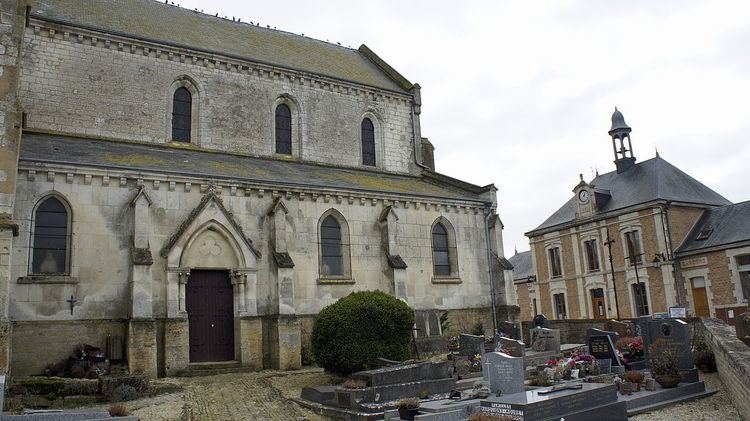
Religious heritage
The commune has one religious building that is registered as an historical monument: