
Intercommunality Pays Rignacois Area 24.34 km² | Region Occitanie Canton Rignac Population (2010) 832 Local time Friday 9:01 AM | |
 | ||
Weather 10°C, Wind E at 23 km/h, 74% Humidity | ||
Auzits is a French commune in the Aveyron department in the Occitanie region of southern France.
Contents
- Map of 12390 Auzits France
- Geography
- Middle Ages
- Contemporary era
- Administration
- Demography
- Civil heritage
- Religious heritage
- Notable people linked to the commune
- References
Map of 12390 Auzits, France
The inhabitants of the commune are known as Auzitois or Auzitoises.
Geography
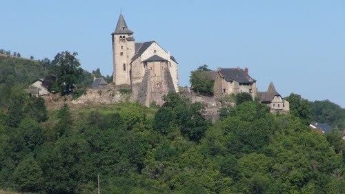
Auzits is located at the top of a hill with the church dominating the valley some 10 km south-east of Decazeville and 28 km north-west of Rodez. It is a large, green, and hilly commune ranging from the Plateau of Hymes to Ruhle le Haut with many vantage points especially from the highest point in the commune at Hautesserre where there is a 360 degree panorama. Access to the commune can be by many routes: the D840 from Firmi in the north passes down the eastern side of the commune and continues south-east to Saint-Christophe-Vallon; the D87 branches from the D840 in the commune and goes south-west then north to the village then west to Montbazens; the D53 from Cransac in the north passes south through the west of the commune going to Bournazel; the D189 goes south from the village towards Goutrens; the D11 comes from Cransac through the village and continues to Saint-Cristophe-Vallon; and the D631 goes north from the village to join the D840 north of the commune. A railway line passes through the commune from north to south with the Auzits-Aussibal Halt near Aussibel. Apart from the village there are the hamlets of Rulhe, Les Escabes, La Berthoumarie, Le Mas del Bosc, Aussibal, Hymes, Plateau d'Hymes, Le Coustal, and Reyrols. The commune is mixed forest and farmland.
The Riou Viou flows from the south through the village then turns west along the northern border and continues to join the Riou Mort at Viviers. The Riou Mort flows north through the east of the commune and continues north-west to join the Lot at Penchot.
Middle Ages
In the Middle Ages Auzits was an important step for pilgrims as it lies on the road to Saint Jacques de Compostela (the path from Conques to Villefranchois). Near the present village there was a small chapel called the Chapel of the Hospital which welcomed the sick, tired, or dying. Under the responsibility of the Knights of the Order of St. John of Jerusalem, the chapel adjoining the hospice is today still in good condition.
In 1358 the English invaded the commune and stayed for thirty years. In 1398, after the withdrawal of the British, the fortified Chateau of Auzits was abandoned. Its inhabitants did not wish for another Lord so collectively decided to build the new village church on the ruins of this castle. Perched on the rocky outcrop overlooking the valley on massive buttresses, the tower was converted into a bell tower. The stones of the second tower were reused for the central nave of the church, which is the present Church of Saint-Maurice.
Contemporary era
During the 19th and 20th centuries the commune experienced spectacular development by the coal industry. The many families who lived on coal-mining declined in number due to successive mine closures in Decazeville basin, leaving only remnants that are still visible on the Rulhe road.
Administration
List of Successive Mayors
(Not all data is known)
Demography
In 2010 the commune had 832 inhabitants. The evolution of the number of inhabitants is known from the population censuses conducted in the commune since 1793. From the 21st century, a census of communes with fewer than 10,000 inhabitants is held every five years, unlike larger communes that have a sample survey every year.
Sources : Ldh/EHESS/Cassini until 1962, INSEE database from 1968 (population without double counting and municipal population from 2006)
Civil heritage
Religious heritage
The commune has one religious building that is registered as an historical monument: