
Area 34.53 km² | Population (2010) 79 Local time Friday 9:01 AM | |
 | ||
Weather 4°C, Wind E at 11 km/h, 60% Humidity | ||
Auzet is a French commune in the Alpes-de-Haute-Provence department in the Provence-Alpes-Côte d'Azur region of south-eastern France.
Contents
- Map of 04140 Auzet France
- Geography
- Natural and technological hazards
- Habitat
- Toponymy
- History
- Administration
- Demography
- Overview
- Agriculture
- Industry
- Service activities
- Local culture and heritage
- References
Map of 04140 Auzet, France
The inhabitants of the commune are known as Auzetans or Auzetanes.
Geography
Auzet is located some 45 km north-east of Sisteron and 35 km west by south-west of Barcelonnette. Access to the commune is by the D7 road from Seyne in the north which passes through the length of the commune and the village and joins the D900A on the southern border of the commune. Apart from the village there are the hamlets of L'Infernet, L'Infernet Haut, and L'Infernet Bas north of the village. The commune is very rugged with snow-capped mountains and forested slopes with 1,168 hectares of forest.
Numerous streams rise mostly in the north of the commune and flow south: the Grave river rises in the north of the commune and gathers countless tributaries as it flows south to join the Bés on the southern border; on the western side the Ravin de Gau, the Ravin de Garnier, the Grave des Planes, and the Ravin du Passavoux all converge with other tributaries to join the Grave; in the east the Ravin du Tourondet, the Ravin du Mairague, and the Ravin du Lausier all flow south and merge to form the Ruisseau de Compolin which continues south to join the Mardaric south of the commune.
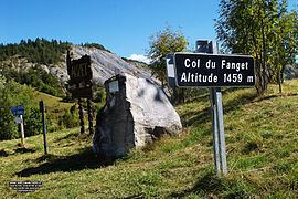
The area of the commune is 3,453 hectares and its altitude varies between 1,068 and 2,028 metres. The village is located at 1,180 m above sea level. The highest peaks are the Tête Grosse (Big Head) (2032 m), Clot de Bouc (1962 m) and the cols of Fanget (1459 m) and Grangeasse.
Natural and technological hazards
None of the 200 communes in the department is in a no seismic risk zone. The Canton of Seyne to which Auzet belongs is zone 1b (low risk) according to the deterministic classification of 1991, which is based on the historical seismic activities, and zone 4 (medium risk) according to the probabilistic classification EC8 of 2011. Auzet is also exposed to four other natural hazards:
Auzet is not exposed to any risk of technological origin identified by the prefecture.
No risk prevention plan for foreseeable natural risks (PPR) exists for the commune and there is no DICRIM.
Habitat
In 2013 the commune built two certified passive buildings (heating needs are less than 15 kilowatts m²/year) with four housing units at 1200 m altitude.
The passive concept is the most advanced in the world and is the only one which can dispense with conventional heating. The heating power is provided by 10w/m2 of fresh air (ventilation).
Toponymy
The name Auzet appears for the first time in charters of 1058 under the name Ausitum. In referring to sheep belonging to the Abbey of Saint Victor, Marseille, it appeared as Alisino in 814 with forty inhabitants.
History
In 1958 loggers discovered a deposit of iron and bronze objects dating from the La Tène period: spearheads, knives, and bits for horses.
In 1351 reference was made to the community, or rather to its chaplain, indicating that the priest of the church did not depend on an Abbey. From the 13th to the 18th century there was a mill in the ravine of Saint Andrieu.
The death of Queen Joanna I re-opened a succession crisis at the head of the County of Provence with the cities of the Aix Union (1382-1387) supporting Charles de Duras against Louis I of Anjou. The Auzet community supported Duras until 1386 then switched sides to join the Angevins through patient negotiation by Marie of Blois, widow of Louis I and regent for their son Louis II.
In the 18th century a fair was held in Auzet.
During the French Revolution the commune had a patriotic society formed after the end of 1792.
In the 19th century Auzet was one of the last towns in the region to develop a school: in the survey of 1863 it was among the 17 communes in the department (245) not to possess one and awaited the Jules Ferry laws to install it.
During the Second World War a colony of Jewish children at the Col du Fanget was saved. Joseph Isoard and his brother Armand with their wives Julie and Simone saved Jews from deportation and were therefore distinguished as Righteous among the Nations.
Administration
List of Successive Mayors
(Not all data is known)
Demography
In 2010 the commune had 79 inhabitants. The evolution of the number of inhabitants is known from the population censuses conducted in the commune since 1793. From the 21st century, a census of communes with fewer than 10,000 inhabitants is held every five years, unlike larger communes that have a sample survey every year.
Sources : Ldh/EHESS/Cassini until 1962, INSEE database from 1968 (population without double counting and municipal population from 2006)
Overview
In 2009 the active population stood at 43 people including 7 unemployed (8 in late 2011). These workers are mostly employed (82%) and mostly work outside the commune (68%). Most of the employees in the commune have jobs in services and administration with 14 positions.
At 1 January 2011 businesses active in the commune were divided between farms (8 out of 22 businesses) and the tertiary sector (10 out of 22).
Agriculture
At the end of 2010 the primary sector (agriculture, forestry, fisheries) had eight businesses.
The number of farms, according to the Agreste survey by the Ministry of Agriculture, was 7 in 2010, all livestock. Auzet had suffered a severe loss of farms, losing six of the ten farms present in the commune from 1988 to 2000. The utilized agricultural area (UAA) has increased from 418 hectares in 1988 to 728 hectares in 2010 distributed among cattle (656 ha) and sheep (71 ha).
Auzet is included in the area of the label Apples of Alpes de Haute-Durance.
Industry
At the end of 2010 the secondary sector (industry and construction) had four businesses employing two people.
Service activities
At the end of 2010 the tertiary sector (trades and services) had eight businesses (employing a total of 13 people) plus two institutions in the administrative sector, health and social (one employee).
The main employer is a school of music - the Music and Environment Centre Fontaine de l’Ours created in 1997.
According to the Departmental Observatory of tourism, tourism is very important for the commune with more than five tourist arrivals per capita. Most of the accommodation capacity is non-market. Several tourist accommodation structures exist in the commune:
It is nevertheless second homes that weigh heaviest in the capacity of with 83 dwellings affected (nearly two out of three homes are second homes)
Local culture and heritage
The Parish Church, under the patronage of Saint Andrew and Saint Bartholomew, was built in the 15th or 16th century near Riou but was engulfed by a flood that deposited a lot of gravel in 1787, then again in 1807. Despite some partial cleanup work it became very damp. It was demolished in March 1872 and its reconstruction was completed in 1874. The current nave is 11 m long, 6 m wide and 8.5 m high; the chevet is 6.4 m long. The spire rises to 22.8 m in height. The church contains a silver Ciborium (17th century) which is registered as an historical object.
The Water gap of Verdaches where an ancient cache of arms was found in 1958.