
Location Nordland, Norway Length 40 km (25 mi) Highest elevation 1,146 m (3,760 ft) Elevation 1,146 m Peak Higravstinden | Archipelago Lofoten Width 30 km (19 mi) Highest point Higravstinden Area 526.7 km² Island group Lofoten | |
 | ||
Points of interest Trollfjord, Svolværgeita, Lofoten Krigsminnenmuseum, Lofotakvariet, Lofotmuseet | ||
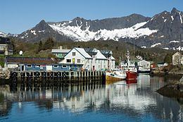
Austvågøy or Austvågøya is the northeasternmost of the larger islands in the Lofoten archipelago in Nordland county, Norway. It is located between the Vestfjorden and the Norwegian Sea. The island of Vestvågøya lies to the southwest and the large island of Hinnøya to the northeast.
Contents
Map of Austv%C3%A5gs%C3%B8ya, Norway
Most of the island is part of Vågan municipality, while the northeastern part belongs to Hadsel municipality. The main town on the island is Svolvær. Austvågøya is popular among mountain climbers. The famous Trollfjord is located in the eastern part of the island. Austvågøy is connected by the European route E10 highway to the neighboring island of Hinnøya in the east using the Raftsund Bridge and to the island of Gimsøya in the west using the Gimsøystraumen Bridge.
Geography
The 526.7-square-kilometre (203.4 sq mi) island is 40 kilometres (25 mi) long in the east to west direction and 30 kilometres (19 mi) wide from the north to south. The islands surrounding Austvågøya include Gimsøya and Vestvågøya to the west, Skrova, Litlmolla, and Stormolla to the south, Hinnøya to the east, and Hadseløya to the north.
Austvågøya is largely a mountain massif, with lowland almost exclusively at the coastal beaches, the brim of lowland around the coast. The highest mountain on the island (and in all of Lofoten) is the 1,146-metre (3,760 ft) tall Higravstinden, located on the eastern part of the island. Svartsundtindan (1,050 metres or 3,440 feet), Trolltindan (1,045 metres or 3,428 feet), and Olsanestind (1,000 metres or 3,300 feet) are also in the eastern part, while the famous Vågakallen (942 metres or 3,091 feet) looms over Henningsvær in the southwestern part.
Name
The Old Norse form of the name was Vágøy. The first element is the name of the old church site at Vågan where Vågan Church is located today. The last element is øy which means "island". The word aust (meaning "east") was later added to the name to differentiate it with the neighboring island of Vestvågøya.