
 | ||
The cape reinga at the end of the aupouri peninsula in northland new zealand
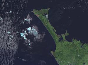
The Aupouri Peninsula is a tombolo at the northern tip of the North Island of New Zealand. It projects between the Tasman Sea to the west and the Pacific Ocean to the east. It constitutes the northern part of the Far North District, incorporating North Cape, Houhora and the northern half of Awanui.
Contents
Overview
It is a peninsula on a peninsula, being part of the massive North Auckland Peninsula which makes up nearly one twelfth of New Zealand's land area. Close to the northern town of Kaitaia, the North Auckland Peninsula suddenly narrows from a width of 60 kilometres to a mere 10 kilometres, a width which it maintains approximately for the last 100 kilometres of its thrust to the north.
At the base of the peninsula to the east is the natural inlet of the Rangaunu Harbour. Beyond this lies a further short peninsula and the broad sweep of Doubtless Bay. The east coast of the peninsula is dominated by Rangaunu Bay in the south and Great Exhibition Bay in the north. Towards its northern tip is the natural inlet of Parengarenga Harbour, beyond which lies North Cape. Spirits Bay and Tom Bowling Bay are located on northernmost of the land.
The peninsula's best-known feature is on the other coast: almost the entire west coast is the 88-kilometre long Ninety Mile Beach.
At its northern end, the peninsula widens to 30 kilometres. Here there are several capes that appear to be the northernmost point of New Zealand's main islands: Cape Maria van Diemen, North Cape, Cape Reinga, and the Surville Cliffs, which is the actual northernmost point by a few hundred metres, at latitude 34° 23' 47" South. Only a handful of islands in the Three Kings and Kermadec chains lie further north in New Zealand.
Although there are a number of settlements with over 100 people, including Te Hapua, Te Kao, Pukenui and Kaimaumau, the peninsula is sparsely inhabited, with a population of approximately 1600. For this reason, the area's roads are largely only metalled rather than being sealed. The main road (State Highway 1) is sealed, the final section completed in April 2010. Ninety Mile Beach is a designated highway, but most rental contracts include it in "prohibited roads". The nearest town to the capes at the tip of the peninsula is Kaitaia, 100 kilometres to the south.
It is named after Te Aupōuri, one of the Māori tribes that inhabits it.