
Area 9.06 km² Local time Thursday 12:48 PM | Region Normandy Canton Aumale Time zone CET (UTC+1) Population 2,577 (1999) | |
 | ||
Weather 9°C, Wind W at 34 km/h, 52% Humidity | ||
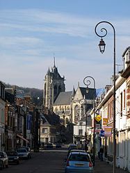
Aumale, formerly known as Albemarle, is a commune in the Seine-Maritime department in the Haute-Normandie region in north-western France. It lies on the Bresle.
Contents
Map of 76390 Aumale, France
History
The town's Latin name was Alba Maria. It was raised by William the Bastard into a county, which was held by the houses of Castile, Dammartin, Harcourt, and Lorraine. In 1547, it was raised to the status of a duchy for Francis of Lorraine. It passed to the house of Savoy, from whom Louis XIV purchased the title in 1675 in order to bestow it upon one of his bastards as an appanage. In 1769, it passed to the house of Orleans. The British Earls of Albemarle, meanwhile, also derive their name from the area.
Geography
A village of farming and associated light industry, situated in the valley of the Bresle River of the Norman Pays de Bray in Normandy on the border with Picardie. It is around 34 miles (55 km) southeast of Dieppe at the junction of the D 916, D 920, D 929 and D 49 roads. The A29 autoroute (Saint-Quentin-Beuzeville) passes through the commune’s northern sector. SNCF, the French railway has a TER station here, on the Beauvais – Le Tréport-Mers line.