
Demonym(s) Audnedøl Area 251.4 km² Local time Wednesday 7:35 PM | Area rank 303 in Norway Time zone CET (UTC+1) Population 1,750 (2016) District Southern Norway | |
 | ||
Weather 1°C, Wind SW at 5 km/h, 96% Humidity Points of interest The old post office, Teinelaget, Sannen, Sannan, The hill fort at Åbestad | ||
Audnedal is a municipality in Vest-Agder county, Norway. It is located in the traditional district of Sørlandet. The administrative centre of the municipality is the village of Konsmo. Other villages in Audnedal include Byremo and Vivlemo. The municipality encompasses the upper half of the Audnedalen valley, and the municipality of Lindesnes (to the south) covers the southern half of the valley.
Contents
- Map of Audnedal Norway
- General information
- Name
- Coat of arms
- Churches
- Government
- Municipal council
- Geography
- Attractions
- References
Map of Audnedal, Norway
The municipality is served by the Audnedal Station along the Sørlandet Line. The railway station is near Konsmo. The railroad heads west from Audnedal and goes through the Hægebostad Tunnel, one of the longest railroad tunnels in Norway.
General information
The old municipality of Undal was established in 1 January 1838 (see formannskapsdistrikt). That municipality only existed until 1845 when it was split into Nord-Audnedal and Sør-Audnedal. Those municipalities were later divided also. Sør-Audnedal was divided into Spangereid in 1899 and Nord-Audnedal was divided into Konsmo and Vigmostad in 1911. During the 1960s, there were many municipal mergers across Norway due to the work of the Schei Committee. This is when the present-day municipality of Audnedal was created. Audnedal was established as a municipality on 1 January 1964 when the municipality of Konsmo (population: 712), the municipality of Grindheim (population: 701), and the Ågedal and Midtbø areas (population: 96) of Bjelland municipality were merged together. This new Audnedal municipality mostly corresponded to the historical borders of the old municipality of Nord-Audnedal.
Name
The municipality was named after the Audnedalen valley in which it is located. The Old Norse form of the name was Auðnudalr. The first element is the genitive case of the river name Auðna (now Audna) and the last element is dalr which means "valley" or "dale". The river name is derived from the Norse word auðn which means "destruction" (because of flooding).
Coat-of-arms
The coat-of-arms is from modern times; they were granted on 30 August 1991. It shows a silver or white blade of a circular saw on a green background. This symbol was chosen to represent the timber and forestry industries in the municipality.
Churches
The Church of Norway has two parishes (sokn) within the municipality of Audnedal. It is part of the Mandal deanery in the Diocese of Agder og Telemark.
Government
All municipalities in Norway, including Audnedal, are responsible for primary education (through 10th grade), outpatient health services, senior citizen services, unemployment and other social services, zoning, economic development, and municipal roads. The municipality is governed by a municipal council of elected representatives, which in turn elect a mayor.
Municipal council
The municipal council (Kommunestyre) of Audnedal is made up of 17 representatives that are elected to every four years. Currently, the party breakdown is as follows:
Geography
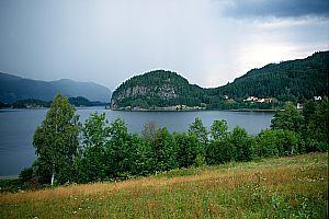
Audnedal is an inland municipality, located in the Audnedalen valley which follows the river Audna. The municipality of Åseral borders it to the north, Hægebostad to the west, Lyngdal and Lindesnes to the south, and Marnardal to the east. To the northeast, Audnedal borders the municipality of Evje og Hornnes in neighboring Aust-Agder county.
Audnedal municipality has two large lakes: Ytre Øydnavatnet and Øvre Øydnavatnet. The Mandalselva river also passes through the northern part of the municipality.