
Intercommunality Estuaire de la Dives Area 2.62 km² | Region Normandy Canton Dozulé Population (2010) 487 Local time Wednesday 10:02 AM | |
 | ||
Weather 7°C, Wind S at 14 km/h, 88% Humidity | ||
Auberville is a French commune in the Calvados department in the Normandy region of north-western France.
Contents
- Map of Auberville France
- Geography
- Toponymy
- History
- Administration
- Demography
- Sites and monuments
- Notable people linked to the commune
- References
Map of Auberville, France
The inhabitants of the commune are known as Aubervillais or Aubervillaises.
Geography
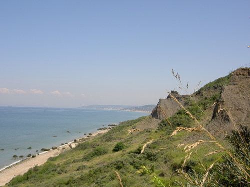
Auberville is located on the northern Normandy coast some 8 km east by north-east of Cabourg and 13 km south-west of Deauville. Access to the commune is by road D513 from Houlgate in the west which passes through the village and continues north-east to Villers-sur-Mer. The D163 branches off the D513 in the village and goes south to Branville. Apart from the village there are the hamlets of Les Genets, Les Bruyeres, and Le Manoir. The north of the commune is forested along the coast with slopes down to the beach while the rest of the commune is farmland.
Toponymy
The name was attested in the form Osbertivilla in 1082. It came from the Germanic anthroponym Osbert or alternatively from the Scandinavian Osbern and the old French ville (from the latin villa) in its original sense of "rural domain".
History
Archaeological excavations have found Merovingian tombs.
Administration
List of Successive Mayors
(Not all data is known)
Demography
In 2010 the commune had 487 inhabitants. The evolution of the number of inhabitants is known from the population censuses conducted in the commune since 1793. From the 21st century, a census of communes with fewer than 10,000 inhabitants is held every five years, unlike larger towns that have a sample survey every year.
Sources : Ldh/EHESS/Cassini until 1962, INSEE database from 1968 (population without double counting and municipal population from 2006)