
Country United States FIPS code 01-03028 Elevation 166 m Zip code 35954 Local time Wednesday 12:18 AM | Time zone Central (CST) (UTC-6) GNIS feature ID 0157880 Area 18.1 km² Population 5,980 (2013) Area code 256 | |
 | ||
Weather 16°C, Wind S at 5 km/h, 93% Humidity | ||
Help attalla alabama traffic speeding ticket lawyer best attalla al traffic attorney
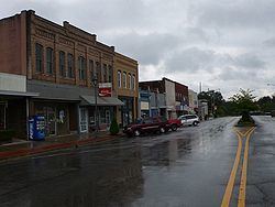
Attalla is a city in Etowah County, Alabama, United States. As of the 2010 census, the population was 6,048.
Contents
- Help attalla alabama traffic speeding ticket lawyer best attalla al traffic attorney
- Map of Attalla AL USA
- A gci church planting story attalla alabama
- History
- 20th century to present
- Geography
- 2000 Census data
- 2010 census
- Education
- Notable people
- References
Map of Attalla, AL, USA
A gci church planting story attalla alabama
History
The town occupies the site of an Indian village which was of considerable importance during the Creek War. It was in Attalla that David Brown, a Cherokee assisted by the Rev. D. S. Butterick, prepared the Cherokee Spelling Book.
Attalla was not founded until 1870, on land donated by W. C. Hammond, a plantation owner. It was incorporated as a city government on February 5, 1872. The town was officially named "Attalla" in 1893, from the Cherokee language word meaning "mountain". Attalla was prosperous until the railroads that it depended on went into bankruptcy.
Attalla is the site of the first hydroelectric dam to provide electricity for a city, constructed in 1887.
20th century to present
William Lewis Moore, a U.S. postman and white civil rights activist, was murdered here on April 23, 1963 as he tried to walk from Chattanooga, Tennessee to Jackson, Mississippi to deliver his letter in support of civil rights to Mississippi Governor Ross Barnett. The suspected murderer, Floyd Simpson, was never charged with the crime.]].
Geography
Attalla is in Etowah County at 34°0′35″N 86°5′54″W (34.009818, -86.098413). It is bordered to the east by the city of Gadsden, the county seat, and at its southernmost point by Rainbow City.
Interstate 59 runs along the eastern edge of the city, with access from Exits 181 and 183. U.S. Route 11 passes through the center of town as Third Street and runs generally parallel to I-59, leading northeast 36 miles (58 km) to Fort Payne and southwest 58 miles (93 km) to Birmingham. U.S. Routes 278 and 431 also pass through the center of Attalla, leading east 5 miles (8 km) to downtown Gadsden. US 431 runs north 20 miles (32 km) to Albertville, while US 278 leads west 47 miles (76 km) to Cullman. Alabama State Route 77 passes through the southern section of Attalla, leading north 3 miles (5 km) to US 431 and southeast 6 miles (10 km) to Rainbow City.
According to the U.S. Census Bureau, the city has a total area of 7.0 square miles (18.1 km2), all of it land. Big Wills Creek, a tributary of the Coosa River, flows southeasterly through the city. The southern end of Lookout Mountain rises to the east overlooking the city.
2000 Census data
As of the census of 2000, there were 6,795 people, 2,672 households, and 1,976 families residing in the city. The population density was 988.0 people per square mile (381.6/km2). There were 2,914 housing units at an average density of 436.7 per square mile (168.7/km2). The racial makeup of the city was 78.42% White, 13.5% Black or African American, 1.5% Native American, 0.08% Asian, 1.64% from other races, and 0.67% from two or more races. 2.22% of the population were Hispanic or Latino of any race.
There were 2,620 households out of which 30.2% had children under the age of 18 living with them, 47.6% were married couples living together, 16.4% had a female householder with no husband present, and 31.5% were non-families. 29.0% of all households were made up of individuals and 13.9% had someone living alone who was 65 years of age or older. The average household size was 2.45 and the average family size was 3.00.
In the city, the population was spread out with 23.7% under the age of 18, 8.9% from 18 to 24, 27.3% from 25 to 44, 22.4% from 45 to 64, and 17.7% who were 65 years of age or older. The median age was 38 years. For every 100 females there were 90.2 males. For every 100 females age 18 and over, there were 86.5 males.
The median income for a household in the city was $27,444, and the median income for a family was $39,549. Males had a median income of $30,605 versus $19,693 for females. The per capita income for the city was $15,727. About 16.4% of families and 18.6% of the population were below the poverty line, including 22.5% of those under age 18 and 22.0% of those age 65 or over.
2010 census
As of the census of 2010, there were 6,048 people, 2,442 households, and 1,627 families residing in the city. The population density was 983.9 people per square mile (381/km2). There were 2,841 housing units at an average density of 424 per square mile (164.2/km2). The racial makeup of the city was 81.5% White, 12.7% Black or African American, .4% Native American, 0.5% Asian, 2.9% from other races, and 2.0% from two or more races. 4.7% of the population were Hispanic or Latino of any race.
There were 2,442 households out of which 27.0% had children under the age of 18 living with them, 42.5% were married couples living together, 18.1% had a female householder with no husband present, and 33.4% were non-families. 29.8% of all households were made up of individuals and 13.0% had someone living alone who was 65 years of age or older. The average household size was 2.41 and the average family size was 2.07.
In the city, the population was spread out with 22.7% under the age of 18, 8.9% from 18 to 24, 25.0% from 25 to 44, 26.3% from 45 to 64, and 17.2% who were 65 years of age or older. The median age was 39.8 years. For every 100 females there were 89.3 males. For every 100 females age 18 and over, there were 94.9 males.
The median income for a household in the city was $32,426, and the median income for a family was $35,934. Males had a median income of $33,428 versus $25,441 for females. The per capita income for the city was $16,457. About 13.9% of families and 18.2% of the population were below the poverty line, including 27.5% of those under age 18 and 13.9% of those age 65 or over.
Education
The Attalla City School System is the public school district. As of 2006 it has some 1,823 students.
The district includes the following schools: