
Country United States FIPS code 29-02422 Elevation 275 m Zip code 63530 Local time Tuesday 4:18 PM | Time zone Central (CST) (UTC-6) GNIS feature ID 0713468 Area 88 ha Population 382 (2013) Area code 660 | |
 | ||
Weather 23°C, Wind SW at 26 km/h, 44% Humidity | ||
Atlanta is a city in Macon County, Missouri, United States. The population was 385 at the 2010 census.
Contents
- Map of Atlanta MO 63530 USA
- History
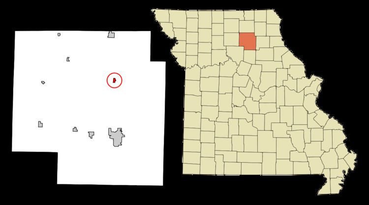
- Geography
- 2010 census
- 2000 census
- Churches
- Annual events
- Education
- Recreation
- Notable residents
- References
Map of Atlanta, MO 63530, USA
History
Atlanta was platted in 1858. The community was named after Atlanta, Georgia. A post office called Atlanta has been in operation since 1868.
On May 6, 1935 a TWA airlines DC-2 en route from Los Angeles, California, to Washington, D.C., became lost in heavy fog near Atlanta. Running out of fuel, the pilot attempted an emergency landing but crashed, which killed four and injured several others. Among the dead was United States Senator Bronson Cutting (R-New Mexico). The crash made national headlines and prompted Congress to commission the Copeland Committee report on air traffic safety.
Geography
Atlanta is located at 39°53′57″N 92°28′49″W (39.899177, -92.480161). According to the United States Census Bureau, the city has a total area of 0.34 square miles (0.88 km2), all of it land.
2010 census
As of the census of 2010, there were 385 people, 157 households, and 104 families residing in the city. The population density was 1,132.4 inhabitants per square mile (437.2/km2). There were 189 housing units at an average density of 555.9 per square mile (214.6/km2). The racial makeup of the city was 97.1% White, 0.3% African American, 0.5% Native American, and 2.1% from two or more races. Hispanic or Latino of any race were 0.3% of the population.
There were 157 households of which 38.2% had children under the age of 18 living with them, 45.2% were married couples living together, 14.6% had a female householder with no husband present, 6.4% had a male householder with no wife present, and 33.8% were non-families. 30.6% of all households were made up of individuals and 14.7% had someone living alone who was 65 years of age or older. The average household size was 2.45 and the average family size was 2.99.
The median age in the city was 37.9 years. 28.1% of residents were under the age of 18; 5.1% were between the ages of 18 and 24; 28.6% were from 25 to 44; 22.1% were from 45 to 64; and 16.1% were 65 years of age or older. The gender makeup of the city was 47.3% male and 52.7% female.
2000 census
As of the census of 2000, there were 450 people, 173 households, and 129 families residing in the city. The population density was 1,314.2 people per square mile (511.0/km²). There were 199 housing units at an average density of 581.2/sq mi (226.0/km²). The racial makeup of the city was 99.11% White, 0.22% Native American, and 0.67% from two or more races.
There were 173 households out of which 39.3% had children under the age of 18 living with them, 56.1% were married couples living together, 15.6% had a female householder with no husband present, and 25.4% were non-families. 23.1% of all households were made up of individuals and 8.7% had someone living alone who was 65 years of age or older. The average household size was 2.60 and the average family size was 3.03.
In the city the population was spread out with 30.7% under the age of 18, 7.8% from 18 to 24, 30.7% from 25 to 44, 18.9% from 45 to 64, and 12.0% who were 65 years of age or older. The median age was 31 years. For every 100 females there were 90.7 males. For every 100 females age 18 and over, there were 84.6 males.
The median income for a household in the city was $33,571, and the median income for a family was $39,271. Males had a median income of $25,673 versus $16,875 for females. The per capita income for the city was $14,940. About 7.3% of families and 9.1% of the population were below the poverty line, including 8.5% of those under age 18 and 11.5% of those age 65 or over.
Churches
The Atlanta community is home to several churches including: The Atlanta First Baptist Church, Atlanta Christian Church, Atlanta United Methodist Church, and Church WithOut Walls, a non-denominational ministry based in the community. Three rural churches are also a part of the Atlanta community: Mt. Zion East United Methodist Church, and Southern Baptist congregations at Chariton Ridge and Mt. Tabor.
Annual events
The community hosts the "Atlanta Homecoming" every June in the town center, Atterberry Park.
Education
The local school district, Atlanta C-3 school district averages about 200 students, K-12, annually.
Recreation
Visitors to the area include hunters seeking whitetail deer and turkey. Hotels are available in Macon, Missouri, La Plata, Missouri and Kirksville, Missouri as well.