
Country Ireland Time zone WET (UTC+0) Website www.athy.ie Population 10,490 (2011) Province Leinster | Irish Grid Reference S680939 Elevation 71 m Local time Tuesday 9:01 PM | |
 | ||
Weather 6°C, Wind W at 21 km/h, 86% Humidity | ||
Athy town co kildare ireland
Athy (/əˈθaɪ/; Irish: Baile Átha Í, meaning "town of the ford of Ae") is a market town at the meeting of the River Barrow and the Grand Canal in south-west County Kildare, Ireland, 72 kilometres southwest of Dublin.
Contents
- Athy town co kildare ireland
- Map of Athy Co Kildare Ireland
- Ireland famine movie athy co kildare
- History
- A centre of Hiberno English
- The birth of motor racing
- British racing green
- Historic places of interest
- Notable people
- Road
- Rail
- Bus
- Sport
- Twinning
- References
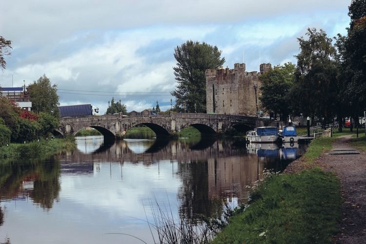
Map of Athy, Co. Kildare, Ireland
A population of 10,490 (2011 Census preliminary results) makes it the sixth largest town in Kildare and the 50th largest in the Republic of Ireland, with a growth rate of 58% since the 2002 census. From the first official records in 1813 (population 3,192) until 1891 (population 4,886) and again in 1926–46 and 1951–61 Athy was the largest town in Kildare. In 1837 the population was 4,494.
It has recently entered the news because of a suspect device found by a member of the public on 15 November 2016.
Ireland famine movie athy co kildare
History
Athy or Baile Átha Í is named after a 2nd-century chieftain, Ae, who is said to have been killed on the river crossing, thus giving the town its name "the town of Ae's ford". The earliest maps show development on the river Barrow i the area, Ptolemy's map of Ireland circa 150AD clearly names the Rheban district as Rheba.
The town developed from a 12th-century Anglo-Norman settlement to an important stronghold on the local estates of the FitzGerald earls of Kildare, who built and owned the town for centuries.
The Confederate Wars of the 1640s were played out in many arenas throughout Ireland and Athy – for a period of eight years – was one of the centres of war involving the Royalists, Parliamentarians and the Confederates. The town was bombarded by cannon fire many times and the Dominican Monastery, the local castles and the town's bridge (dating from 1417) all succumbed to the destructive forces of the cannonball. The current bridge, the Crom-a-Boo Bridge, was built in 1796.
The first town charter dates from 1515 and the town hall was constructed in the early 18th century. The completion of the Grand Canal in 1791, linking here with the River Barrow, and the arrival of the railway in 1846, illustrate the importance of the town as a commercial centre. From early on in its history Athy was a garrison town loyal to the Crown. English garrisons stayed in the barracks in Barrack Lane after the Crimean War and contributed greatly to the town's commerce. Home for centuries to English soldiers, Athy gave more volunteer soldiers to the Great War of 1914–18 than any other of similar sized town in Ireland.
A centre of Hiberno-English
Athy has evolved as a centre for Hiberno-English, the mix of the Irish and English language traditions. A dialect starting with old Irish beginnings, evolved through Norman and English influences, dominated by a church whose first language was Latin and educated through Irish. Athy in particular was a mixing pot of languages that led to modern Hiberno-English. Positioned at the edge of the Pale, sandwiched between the Irish and English speaking partitions, Athy traded language between the landed gentry, the middle class merchants, the English working class garrison soldiers and the local peasantry. Many locals words borrow from the Irish tradition, such as "bokety", "fooster" or "sleeveen", while words like "kip", "cop-on" or even "grinds" have their origins in Old or Middle English.
This tradition of spoken word led to a lyrical approach to composition and perhaps explains the disproportionate number of writers Athy has produced. Athy becomes subject and object of creative endeavours – the traditional folk song, "Johnny I Hardly Knew Ye", is a prime example. Other songs in this tradition include "Lanigan's Ball" and "Maid of Athy". Another song of note from the area is called "The Curragh Of Kildare", the first song collected by Robbie Burns. Athy is also the surname of a minor character in James Joyce's Portrait of the Artist as a Young Man, who tells Stephen Dedalus, the protagonist, that they both have strange surnames and makes a joke about County Kildare being like a pair of breeches because it has Athy in it. Athy is referenced by Patrick Kavanagh in his poem Lines Written on a Seat on the Grand Canal, Dublin: "And look! a barge comes bringing from Athy/And other far-flung towns mythologies."
The birth of motor racing
On Thursday, 2 July 1903 the Gordon Bennett Cup ran through Athy. It was the first international motor race to be held in United Kingdom of Great Britain and Ireland, an honorific to Selwyn Edge who had won the 1902 event in Paris driving a Napier. The Automobile Club of Great Britain and Ireland wanted the race to be hosted in the British Isles, and their secretary, Claude Johnson (managing director of C.S. Rolls & Co), suggested Ireland as the venue because racing was illegal on British public roads. The editor of the Dublin Motor News, Richard J. Mecredy, suggested an area in County Kildare and letters were sent to 102 Irish MPs, 90 Irish peers, 300 newspapers, 34 chairmen of county and local councils, 34 County secretaries, 26 mayors, 41 railway companies, 460 hoteliers, 13 PPs, plus the Bishop of Kildare and Leighlin, Patrick Foley, who pronounced himself in favour. Local laws had to be adjusted, ergo the 'Light Locomotives (Ireland) Bill' was passed on 27 March 1903. Kildare and other local councils drew attention to their areas, whilst Queen's County declared That every facility will be given and the roads placed at the disposal of motorists during the proposed race. Eventually Kildare was chosen, partly on the grounds that the straightness of the roads would be a safety benefit.
The route consisted of two loops that comprised a figure of eight. The first was a 52-mile (84 km) loop that included Kilcullen, The Curragh, Kildare, Monasterevin, Stradbally and Athy, followed by a 40-mile (64 km) loop through Castledermot, Carlow and Athy again. The race started at the Ballyshannon cross-roads (53.0853°N 6.82°W / 53.0853; -6.82) near Calverstown on the contemporary N78 heading north, then followed the N9 north; the N7 west; the N80 south; the N78 north again; the N9 south; the N80 north; the N78 north again. Competitors were started at seven-minute intervals and had to follow bicycles through the 'control zones' in each town. The 328 miles (528 km) race was won by the famous Belgian Camille Jenatzy, driving a Mercedes in German colours. This race is still celebrated today.
British racing green
Britain had to choose a different colour to its usual national colours of red, white and blue, as these had already been taken by Italy, Germany and France respectively. Red was also stated as the colour for American cars in the 1903 Gordon Bennett Cup. As a compliment to Ireland, the British team chose to race in shamrock green which thus became known as British racing green, although the winning Napier of 1902 had in fact been painted olive green.
Historic places of interest
Athy's courthouse was designed by Frederick Darley and built in the 1850s. The building was originally the town's corn exchange.
The town's pub, Frank O'Brien's Bar, is considered a tourist attraction and was voted one of the top ten Irish bars in the Sunday Tribune in 1999. Hardware merchants Griffin Hawe now occupy the town's 6 ft. wide and 12 ft. high 18th century cockpit.
Notable people
Road
The town is located on the N78 national secondary road where it crosses the R417 regional road. In 2010 the N78 was re-aligned so that it no longer heads from Athy towards Kilcullen and Dublin via Ardscull, but now connects with the M9 motorway near Mullamast. The old Athy-Kilcullen section of the road previously known as the N78 is now the R418.
Rail
Athy is connected to the Irish rail network via the Dublin–Waterford main line. Athy railway station opened on 4 August 1846 and closed for goods traffic on 6 September 1976. There is a disused siding to the Tegral Slate factory (formerly Asbestos Cement factory). This is all that is left of the former branch to Wolfhill colliery. This side line was built by the United Kingdom government in 1918 due to wartime shortage of coal in Ireland. The concrete bridge over the River Barrow on this branch is one of the earliest concrete railway under bridges in Ireland.
Bus
Bus Éireann route 7 and JJ Kavanagh's route 717 also provide frequent services to Athy. Bus Éireann route 130 also serves the town but in one direction only. South Kildare Community Transport also operate two routes from the town serving outlying villages and rural areas
Sport
Twinning
In 2003, the town became twinned with the French town of Grandvilliers in the Oise-Picardy département. The French twinning committee is named "La Balad'Irlandaise", and official visits take place every two years, while musical and student exchanges take place more regularly.