
Width 4 km (2.5 mi) Highest point Vettafjellet Area 20 km² | Length 7 km (4.3 mi) Highest elevation 372 m (1,220 ft) Municipality Tingvoll | |
 | ||
Boligfelt asp ya
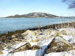
Aspøya is an island in Tingvoll Municipality in Møre og Romsdal county, Norway. It is located between the Freifjorden and the Tingvollfjorden. The European route E39 highway crosses Aspøya and connects it to the nearby island of Bergsøya to the west by the Bergsøysund Bridge–part of the Krifast system. To the east, the E39 highway connects it to the Straumsnes peninsula in Tingvoll.
Contents
Map of Asp%C3%B8ya, 6670 %C3%98ydegard, Norway
The highest point on the 20-square-kilometre (7.7 sq mi) island is the 372-metre (1,220 ft) mountain Vettafjellet. While often considered an island, it is technically a peninsula that is connected by a narrow 150-metre (490 ft) wide Nålsundeidet isthmus of land, which was excavated in 1905 to provide a small 8-m-wide canal for boats to travel through.
Asp ya
References
Aspøya Wikipedia(Text) CC BY-SA