
County Örebro County Founded 1643 Area 2.78 km² Local time Sunday 8:15 PM | Municipality Askersund Municipality Elevation 101 m (331 ft) Population 3,887 (31 Dec 2010) | |
 | ||
Weather 0°C, Wind SW at 5 km/h, 95% Humidity | ||
Askersund is a locality and the seat of Askersund Municipality, Örebro County, Sweden with a population census of 3,887 inhabitants in 2010.
Contents
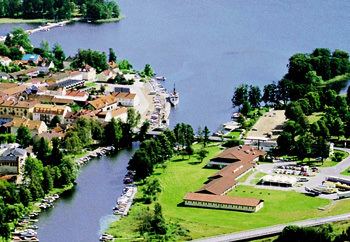
Map of Askersund, Sweden
Geography
Askersund is a popular tourist destination with swimming and nature experiences. The city centre is still marked by its wooden buildings and their two churches. Sophia Magdalena was designed by Olof tempelman and Askersund country Church by Jean de la Vallée and Erik Dahlberg. The city is located on the edge of the forest of Tiveden at Lake Alsen forming North of Lake Vättern and along the lake, just outside the city is Husabergsudde with bathing and camping. From the city, it has views of Lake Vättern and Tivedsskogen. On the other side of the water is Prince Gustaf's Castle, Stjernsund.
History
The town Askersund traces its origin from the 14th century. In 1643, it was significant enough to receive its charter as one of the cities in Sweden. Despite its small size, Askersund is for historical reasons normally still referred to as a city, although Statistics Sweden nowadays defines a city as a locality with more than 10,000 inhabitants.
In the 19th century, Askersund was planned to be the site of one of the two supply fortresses for Karlsborg Fortress, located on an island in Lake Vättern, now belonging to Karlsborg Municipality. In 1812, Askersunds flickskola, the second institution to give females higher education in Sweden, was founded in Askersund.