
 | ||
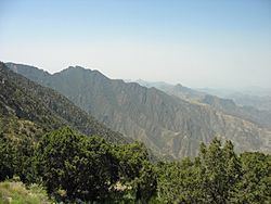
The Asir mountains (Arabic: عسير ʿsyr [ʕsiːr] "difficult") is a mountainous region in southwestern Saudi Arabia running parallel to the Red Sea. It comprises areas in Asir within Saudi Arabia, however it also generally includes areas near the Yemen border. The mountains cover approximately 100,000 square kilometres (40,000 sq mi) and consists of mountains, plains, and valleys of the Arabian highlands.
Contents
- Map of Asir Mountains 24418 Saudi Arabia
- Geology
- Climate and agriculture
- Agriculture
- Biodiversity
- References
Map of Asir Mountains 24418, Saudi Arabia
Geology
The mountains consist primarily of sedimentary rock, limestone, sandstone and shale, of Jurassic, Cretaceous and Paleogene origin on a Precambrian granitic basement.
Climate and agriculture
The region has the highest average rainfall of Saudi Arabia due to largely seasonal rain. Average rainfall can range from 600 millimetres (24 in) to over 1,000 millimetres (39 in) per year, in wet regions. The eastern plains and plateaus receive much lower amounts, from 500 millimetres (20 in) to below 100 millimetres (3.9 in) per year.
Agriculture
The region's crops, most of which are cultivated on steeply terraced mountainsides, include wheat, coffee, cotton, indigo, ginger, vegetables, and palms. The region also supports cattle, sheep, goats, and camels.
Biodiversity
The region's difficult terrain has helped preserve the region's unique biodiversity. Several new Myxomycetes fungi species have been discovered in the region, as have a variety of previously undiscovered plants. Asir is also thought to be one of the last natural habitats of the Arabian leopard.