
 | ||
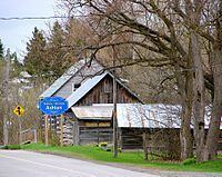
The small village of Ashton is located about 40 kilometres (25 mi) southwest of Ottawa, Ontario, Canada, at the intersection of Ashton Station Road and Flewellyn Road. Ashton Station Road runs through the centre of the community, and serves as the south-western boundary line for the City of Ottawa, thus making the eastern half of the hamlet part of Ottawa, and the western portion part of Lanark County. The eastern half of the community was originally part of Goulbourn Township, which was amalgamated into the City of Ottawa in 2001. It is home to approximately 200 residents.
Contents
Map of Ashton, Ottawa, ON, Canada
The headwaters of the Jock River, which runs through the heart of the community, are just to the west of the hamlet. There is a general store, a pub, several churches and a community center. Unlike many communities surrounding the burgeoning city of Ottawa, Ashton has remained relatively unchanged for many years. Public high school students in this area go to South Carleton High School in Richmond.
Movies filmed in Ashton: The Day
History
The village was first laid out and settled by John Sumner, general merchant and postmaster, on the Goodwood river. By 1866-7, it was in the township of Goulbourne, close to the dividing line between the counties of Carleton and Lanark. It had a population of about 100, and contained two churches-Presbyterian, a stone edifice; and Church of England, also stone; and one common school, with an average attendance of about 40 pupils.