
OS grid reference SU465032 Post town SOUTHAMPTON Local time Sunday 2:47 PM | Sovereign state United Kingdom Postcode district SO45 Dialling code 023 | |
 | ||
Weather 10°C, Wind SW at 35 km/h, 88% Humidity | ||
High tide at ashlett creek near southampton water on 4th november 2013
Ashlett is a small settlement in Hampshire, England. At the 2011 Census the population was included in the civil parish of Fawley. It is at the end of Ashlett Creek, a tidal inlet of Southampton Water. Ashlett is known for having a well-preserved tidal mill (currently a sailing club clubhouse), which is next to a free slipway and landing stage. Although the creek is only accessible at high tide, the historic mill and free landing stage make it a popular destination for dinghy sailors from around Southampton Water.
Contents
- High tide at ashlett creek near southampton water on 4th november 2013
- Map of Ashlett Southampton UK
- Ashlett Creek
- Ashlett Mill
- Governance
- References
Map of Ashlett, Southampton, UK
Ashlett Creek
Ashlett is a natural creek, located down a lane leading from the village of Fawley. At the beginning of the 20th century ships of 100, or even 150 tons, were brought up here at high tide, and unloaded at Victoria Quay. It was used extensively to bring in construction materials when the first refinery was built at Fawley in the 1920s.
There is a pub at Ashlett called the Jolly Sailor.
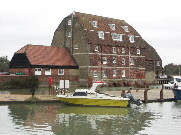
Ashlett Mill
Ashlett Mill is a brick building with a tiled mansard roof. It was built in 1816, replacing an earlier mill. It now serves as a meeting and club house of the Waterside Sports and Social Club and the Ashlett Sailing Club.
Governance
The hamlet of Ashlett is part of the civil parish of Fawley, and part of the Fawley, Blackfield and Langley ward of the New Forest council.