
Country United States FIPS code 48-04300 Elevation 163 m Zip code 78827 Population 1,135 (2013) | Time zone Central (CST) (UTC-6) GNIS feature ID 1377157 Area 210 ha Local time Sunday 7:30 AM Area code 830 | |
 | ||
Weather 11°C, Wind W at 0 km/h, 72% Humidity | ||
Asherton is a city in Dimmit County, Texas, United States. The population was 1,084 at the 2010 census, down from 1,342 at the 2000 census. The estimated population in 2014 was 1,153. U.S. Highway 83 runs through Asherton.
Contents
Map of Asherton, TX 78827, USA
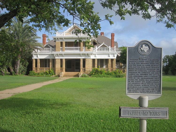
Rancher Asher Richardson built the town after he purchased a huge tract of land in a special state sale. His Asherton Land and Irrigation Company developed 48,000 acres (190 km2). Richardson subsequently funded the Asherton and Gulf Railway Company. The Asher and Mary Isabelle Richardson House (1910), perched on a hill in Asherton, is easily visible from U.S. Highway 83. It is named for a combination of the first names of Richardson and his wife, Mary Isabelle, or Belle. The structure is made of sandstone and is designed in the Prairie school of architecture by the late Alfred Giles of San Antonio. The house has remained in the family for generations.
The Asherton and Gulf Railroad was originally based in Carrizo Springs. From 1905 to 1909, the railroad was known as the Nueces Valley, Rio Grande and Mexico Railway Company. In 1909, 12 miles (19 km) of track opened between Artesia Wells and Light, Texas. By 1910, the last 20 miles (32 km) between Light and Asherton were completed.
Telephone service arrived in 1905, and essential buildings were constructed. In 1909, Asherton obtained a post office. By 1915, the population had reached 1,000, with a bank, hotels, blacksmiths, three stores and a lumber yard. The town was incorporated in 1925. It is one of the few Texas communities which still uses the city commission government. In 1927, it became one of the largest producers of Bermuda onions in the United States. The population peaked in 1954 at 2,425.
Geography
Asherton is located at the center of Dimmit County at 28°26′50″N 99°45′41″W (28.447159, -99.761504). It is on the east side of El Moro Creek, a northeast-flowing tributary of the Nueces River. U.S. Highway 83 leads northwest 8 miles (13 km) to Carrizo Springs, the county seat, and south 72 miles (116 km) to Laredo.
According to the United States Census Bureau, Asherton has a total area of 0.81 square miles (2.1 km2), all of it land.
Demographics
As of the census of 2000, there were 1,342 people, 428 households, and 341 families residing in the city. The population density was 1,609.6 people per square mile (624.3/km²). There were 535 housing units at an average density of 641.7 per square mile (248.9/km²). The racial makeup of the city was 75.56% White, 0.15% African American, 0.15% Native American, 0.07% Asian, 21.39% from other races, and 2.68% from two or more races. Hispanic or Latino of any race were 94.78% of the population.
There were 428 households out of which 42.8% had children under the age of 18 living with them, 56.8% were married couples living together, 18.5% had a female householder with no husband present, and 20.3% were non-families. 18.9% of all households were made up of individuals and 11.2% had someone living alone who was 65 years of age or older. The average household size was 3.13 and the average family size was 3.62.
In the city, the population was spread out with 35.2% under the age of 18, 7.6% from 18 to 24, 23.6% from 25 to 44, 20.8% from 45 to 64, and 12.8% who were 65 years of age or older. The median age was 31 years. For every 100 females there were 87.7 males. For every 100 females age 18 and over, there were 83.2 males.
The median income for a household in the city was $20,417, and the median income for a family was $24,107. Males had a median income of $23,281 versus $17,500 for females. The per capita income for the city was $7,746. About 29.9% of families and 35.8% of the population were below the poverty line, including 40.8% of those under age 18 and 41.8% of those age 65 or over.
Education
Public education in Asherton is provided by the Carrizo Springs Consolidated Independent School District.
Schools that serve Asherton include:
Prior to the fall of 1999, the Asherton Independent School District served Asherton. AISD was forced to close because of concerns about taxation.