
Population (2015) 449 Local time Sunday 2:40 PM | Founded 1979 | |
 | ||
Weather 24°C, Wind NE at 6 km/h, 16% Humidity | ||
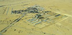
Ashalim (Hebrew: אֲשָׁלִים) is a small communal settlement in southern Israel. Located in the Negev desert about 35 km south of Be'er Sheva and on the eastern side of Nahal Besor, the largest stream in the Negev, it falls under the jurisdiction of the Ramat Negev Regional Council. In 2015 its population was 449. Nearby settlements include Ezuz and Nitzana.
Contents
Map of Ashalim, Israel
History
The new Ashalim was founded as moshav shitufi in 1979 after moving from Bir Asluj Hill close to Golda Park (a nearby artificial lake). It was named after the original village of Ashalim, one of three nahal settlements founded between Mashabei Sadeh and Nitzana in 1956. The name itself means Tamarixes, a genus of shrubs and small trees. Today Ashalim functions as a communal settlement.
In 2003, Kfar Adiel, a village for students of the Ben-Gurion University of the Negev, was founded near Ashalim by the Ayalim Association, whose objective is to establish settlements for students and small entrepreneurs in the Negev and the Galilee.
Economy
Ashalim is one of a number of development sites for solar power in Israel. A 250 MW solar park in Ashalim has been in the planning stages for over five years, but it is not expected to produce power before 2013. In 2008 construction began on three solar power plants near the settlement; two thermal and one photovoltaic.