
Max. depth 80 m (260 ft) | Surface area 58 km (22 sq mi) Area 58 km² | |
 | ||
Max. width 4.18 km (2.60 mi) (at mouth) Settlements | ||
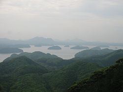
Asō Bay (浅茅湾, Asō-wan) is a deep fjord that nearly cleaves in two the Japanese island of Tsushima. The bay is notable for its ria coastline, with various small islands found in close proximity to the shore. It forms part of the Iki-Tsushima Quasi-National Park. Pearls are cultured and Japanese amberjack are farmed in its waters.
Contents
Map of Aso Bay, Japan
Manzeki Channel
The Manzeki Channel (万関瀬戸) links Asō Bay with Miura Bay (三浦湾), which opens onto the Tsushima Straits. The channel was cut by the Imperial Japanese Navy between 1895 and 1904. Initially twenty-five metres across and three metres deep, it was later enlarged to accommodate bigger vessels.
References
Asō Bay Wikipedia(Text) CC BY-SA