
Country France Department Isère Intercommunality Bièvre-Liers Area 9.79 km² | Region Auvergne-Rhône-Alpes Canton Côte-Saint-André Population (2010) 216 Arrondissement Vienne, Isère | |
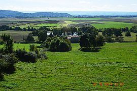 | ||
Arzay is a French commune in the Isère department in the Auvergne-Rhône-Alpes region of south-eastern France.
Contents
- Map of 38260 Arzay France
- Geography
- Administration
- Demography
- Sites and monuments
- Life in the commune
- Notable people linked to the commune
- References
Map of 38260 Arzay, France
The inhabitants of the commune are known as Arzayaux.
Geography
Arzay is located some 27 km east by south-east of Vienne and 25 km south of Villefontaine. Access to the commune is by the minor D51 road (Route de Beaurepaire) from Pommier-de-Beaurepaire in the south-west passing through the heart of the commune south of the village and continuing to Semons in the east. Access to the village can be by several country roads running off the D51 including the Chemin de la Grande Fontaine, the Chemin de la Croix, or the Chemin de la Diligence. The hilly part of the commune north of the village is heavily forested (part of the Forest of Bonnevaux) while the flat commune south of the village is farmland.
A band of "Étangs" - ponds or lakes - crosses the commune in the north from south-west to north-east. The Étangs within the commune are:
The Suzon river flows through the south of the commune from east to west and continues south-west to eventually join the Oron at Beaurepaire. The Grande Vareze flows into the largest of the Étangs in the north - the Étang du Grand Albert.
Administration
List of Successive Mayors
(Not all data is known)
Demography
In 2010 the commune had 216 inhabitants. The evolution of the number of inhabitants is known from the population censuses conducted in the commune since 1793. From the 21st century, a census of communes with fewer than 10,000 inhabitants is held every five years, unlike larger towns that have a sample survey every year.
Sources : Ldh/EHESS/Cassini until 1962, INSEE database from 1968 (population without double counting and municipal population from 2006)