
Length 31 km (19.3 mi) Area 46 km² | Width 24 km (14.9 mi) Administrative subdivision Tuamotus | |
 | ||
Island groups Tuamotu-Gambier Islands, Tuamotus | ||
Arutua, or Ngaru-atua is an atoll in the Tuamotu group in French Polynesia. It is located 40 km SW of Rangiroa. The closest land is Apataki Atoll, only 16 km to the East.
Contents
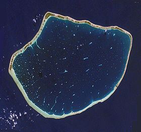
Map of Arutua, French Polynesia
Arutua Atoll has a roughly pentagonal shape. Length 31 km (19 mi) , width 24 km (15 mi) . The lagoon area is 484 km2 (187 sq mi) and the land area is 15 km2 (6 sq mi). Its lagoon is wide and deep with one navigable passage. As of 2012, Arutua had a population of 680 inhabitants. The main village is Rautini. There is a small airport at Arutua which was opened in 1984.
Geographically Arutua belongs to the Palliser Islands (Îles Palliser) subgroup of the Tuamotus.
History
The first recorded European to visit Arutua Atoll was Jakob Roggeveen (who also first sighted Easter Island) in 1722. British mariner Frederick Beechey touched at Arutua in 1826. He named this atoll "Cockburn Island".
Administration
This atoll is the capital of the commune of Arutua, which consists of Arutua, as well as the atolls of Apataki and Kaukura.
Demographics
Table 1. Current population.
Table 2. Population over time.