
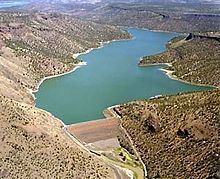
Opening date 1961 Height 75 m Length 244 m | Surface area 3,580 acres (14.5 km) Opened 1961 Total capacity 287.6 million m³ | |
 | ||
Catchment area 2,300 square miles (5,960 km) Similar Ochoco Creek, Prineville Reservoir Wildlife A, Jasper Point (Prinevill, Round Butte Dam, A R Bowman Memorial | ||
Arthur r bowman dam at prineville reservoir
Arthur R. Bowman Dam (also known as Bowman Dam; National ID # OR00579) is an earth-type irrigation dam on the Crooked River in the U.S. state of Oregon. It is in Crook County. Its reservoir is called Prineville Reservoir.
Contents
Map of Bowman Dam, Prineville, OR 97754, USA
The dam was constructed by the United States Bureau of Reclamation in 1961, and is operated by the Ochoco Irrigation District. The Crooked River wild and scenic area, which was designated by the Bureau of Land Management in 1988, passes through the center of Bowman Dam. Due to this designation, hydropower production is currently not allowed at the dam.
In 2015, for the third time, the U.S. House of Representatives passed a Bowman Dam bill, which would authorize the city of Prineville to access about 6 percent more water from the reservoir. As of May 2015, the Bowman Dam bill has not passed the U.S. Senate