
- left Haraszthy Creek - elevation 13 ft (4 m) Basin area 29.53 km² Cities Sonoma | - elevation 1,345 ft (410 m) Basin area 29.53 km² Mouth Schell Creek | |
 | ||
- location 4 mi (6 km) northeast of Sonoma, California - location 4 mi (6 km) south of Sonoma, California | ||
Arroyo seco creek
Arroyo Seco Creek, or simply Arroyo Seco, is a 6.9-mile-long (11.1 km) tributary stream to Schell Creek in southern Sonoma County, California, United States. In Spanish arroyo seco means "dry creek".
Contents
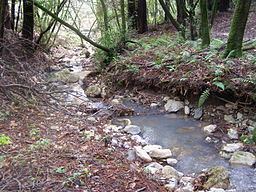
Arroyo Seco Creek drains a portion of the western slopes of the southern Mayacamas Mountains. Its 11.4-square-mile (30 km2) watershed, along with the entire Mayacamas mountain block, was formed in the Miocene era by volcanic action and with tectonic uplift about 12 million years ago.
Soils of the immediate streambed and its vicinity are classified as the riverwash series, recent deposition of sands and gravels.
Arroyo Seco Creek springs near the Napa County line about 4 mi (6 km) northeast of Sonoma, California. It flows southward, emerging from the hills near Sonoma Valley Hospital. After a confluence with Haraszthy Creek, it crosses under State Route 12 near Schellville, California, where it flows into Schell Creek. Schell Creek discharges to a network of sloughs that eventually empty into Sonoma Creek, which in turn empties into the Napa Sonoma Marsh and San Pablo Bay.