
Area 12.14 km² | ||
 | ||
Region Bourgogne-Franche-Comté | ||
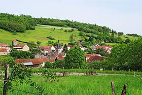
Arnay-sous-Vitteaux is a French commune in the Côte-d'Or department in the Bourgogne-Franche-Comté region of eastern France.
Contents
- Map of 21350 Arnay sous Vitteaux France
- Geography
- Administration
- Demography
- Sites and monuments
- References
Map of 21350 Arnay-sous-Vitteaux, France
The inhabitants of the commune are known as Arnétois or Arnétoises
Geography
Arnay-sous-Vitteaux is located some 50 km north-west of Dijon and 35 km south-east of Montbard. Access to the commune is by the D905 road from Vitteaux in the south passing through the east of the commune and continuing north to Venarey-les-Laumes. Access to the village is by the D1178 from Marigny-le-Cahouët in the north-west passing through the village then north-east to join the D905. There are forests in the west, centre, and east of the commune with the rest being farmland.
The Brenne river passes through the commune from south to north parallel to and west of the D905. The Ruisseau de Chassaigne rises in the south of the commune and flows north through the village to join the Brenne east of the village.
Administration
List of Successive Mayors
(Not all data is known)
Demography
In 2009 the commune had 112 inhabitants. The evolution of the number of inhabitants is known from the population censuses conducted in the commune since 1793. From the 21st century, a census of communes with fewer than 10,000 inhabitants is held every five years, unlike larger towns that have a sample survey every year.
Sources : Ldh/EHESS/Cassini until 1962, INSEE database from 1968 (population without double counting and municipal population from 2006)