
Subregion Algarve Population 4,867 (2011) | Region Algarve Intermunic. comm. Algarve Postal code 8365 | |
 | ||
Weather 17°C, Wind SW at 16 km/h, 64% Humidity Points of interest Praia de Armação de Pêra, Aurora Boat Trips ‑ Algarve C, Fortaleza de Armação | ||
Armação de Pêra is a Portuguese parish (freguesia) in the municipality of Silves. The population in 2011 was 4,867, in an area of 7.99 km². The village used to be called Pêra de Baixo or Lower Pêra to distinguish it from the present Pêra, which was then named Pêra de Cima or Upper Pêra.
Contents
Map of Arma%C3%A7%C3%A3o de P%C3%AAra, Portugal
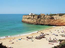
The village of Armação de Pêra is, today, a popular tourist center with fine beaches, hotels, cafés and restaurants. The village is on a broad bay that stretches from Pont da Galé to Senhora da Rocha. Its beaches extend from Praia dos Pescadores or the Fishermans Beach, to Salomão beach, including those of Maré Grande and Beijinhos.
The village is one of the last places in the region where fishing boats are launched from and recovered to the actual beach. There is no harbour.
Location
The village is 20.9 kilometres (13.0 mi) southeast of Silves, 3 kilometres (1.9 mi) from Alcantarilha, 1.5 kilometres (0.93 mi) from Pêra and 264 kilometres (164 mi) south south east of Lisbon.