
Country United States FIPS code 30-02425 Elevation 942 m Zip code 59821 Area code 406 | Time zone Mountain (MST) (UTC-7) GNIS feature ID 0801998 Area 16.8 km² Population 602 (2000) | |
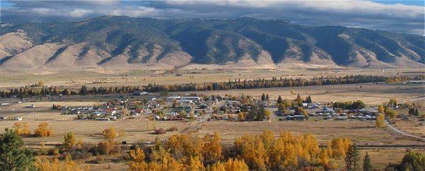 | ||
Arlee (Salish: nɫq̓alqʷ, nɫq̓a ) is a census-designated place (CDP) in Lake County, Montana, United States. The population was 602 at the 2000 census. It is named after Arlee, a Flathead Indian chief.
Contents
Map of Arlee, MT 59821, USA
Geography
Arlee is located at 47°10′9″N 114°5′24″W (47.169154, -114.089899).
According to the United States Census Bureau, the CDP has a total area of 6.5 square miles (17 km2), all of it land.
Demographics
As of the census of 2000, there were 602 people, 235 households, and 161 families residing in the CDP. The population density was 92.8 people per square mile (35.9/km²). There were 268 housing units at an average density of 41.3 per square mile (16.0/km²). The racial makeup of the CDP was 45.85% White, 50.00% Native American, 0.66% from other races, and 3.49% from two or more races. Hispanic or Latino of any race were 5.15% of the population.
There were 235 households out of which 37.0% had children under the age of 18 living with them, 42.1% were married couples living together, 20.4% had a female householder with no husband present, and 31.1% were non-families. 26.8% of all households were made up of individuals and 7.7% had someone living alone who was 65 years of age or older. The average household size was 2.56 and the average family size was 3.14.
In the CDP, the population was spread out with 32.4% under the age of 18, 7.1% from 18 to 24, 28.2% from 25 to 44, 23.4% from 45 to 64, and 8.8% who were 65 years of age or older. The median age was 33 years. For every 100 females there were 104.8 males. For every 100 females age 18 and over, there were 91.1 males.
The median income for a household in the CDP was $21,188, and the median income for a family was $22,125. Males had a median income of $25,500 versus $19,167 for females. The per capita income for the CDP was $11,558. About 37.6% of families and 34.1% of the population were below the poverty line, including 51.2% of those under age 18 and 21.1% of those age 65 or over.
History
Arlee was named after the Salish leader Arlee. In October 1873, he moved a small group of his people from the Bitterroot Valley, which was designated a “conditional reservation” in the 1855 Hellgate Treaty, to the Jocko Agency (later Flathead Indian Agency) located a few miles south of the current town of Arlee. This forced move stemmed from the efforts of a congressional delegation led by future president James Garfield to negotiate Salish removal from the Bitterroot Valley.
Culture
Arlee has an annual summer pow wow celebration, the Arlee Esyapqeyni. Montana Salish is taught at the Nkwusm Salish Immersion School.
Salish is spoken in Arlee. Art is popular, and a gallery displays works by local artists.
Rodeo has been a huge part of arlees's culture. The annual faith of July. Rodeo is held during. Pow wow time and always has both. Native. And. Non native cowboys competing. Many Montana. Rodeo legends and long time. Contenders have lived. Here. Over. The years. Most. Notably the schall family. Whose faMiley members continue to rodeo to this day. Besides the schall family; the lytles, the mapstons, the matts and the hendricksons are all families who have produced good rodeo hands .