
Existed: 1936 – present Constructed 1936 | South end: US 60 near Aguila Length 38.88 km | |
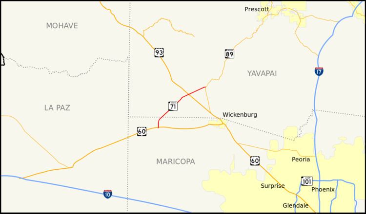 | ||
State Route 71 (or SR 71) is a state highway in central Arizona that stretches between its northeast terminus at its junction with State Route 89 at Congress and its southwest terminus at its junction with U.S. Route 60 at Aguila. It primarily serves as a shortcut between Prescott and the major roads going to California as there are no towns located on the route other than at the ends of the highway.
Contents
Map of AZ-71, Congress, AZ 85332, USA
Route description
The route begins at U.S. Route 60 just east of the city of Aguila. The road bends slightly northeastward before heading straight north, with fields on the west side of the road. After crossing from Maricopa County into Yavapai County, SR 71 then heads northeastward into a desert area, continuing for several miles in a straight direction through the Mojave Desert. While heading northeast, the route meets U.S. Route 93, at the diamond interchange forming the intersection called the Joshua Tree Forest Parkway of Arizona. SR 71 then enters into the town of Congress, which is littered with several small houses. The route ends at an at-grade intersection with Arizona State Route 89.
History
The current road was originally designated a state route in 1936.
Prior to 1936, the SR 71 designation was given to a road from US 180 near Safford to US 60 in Eagar. This previous incarnation of SR 71 had existed since 1927 and was part of the original state highway system introduced by the Arizona State Highway Commission on 9 September 1927. SR 71 was absorbed into SR 81 in 1936 and subsequently SR 81 became an extension of US 666 (now US 191).