
Canton Iholdy Area 5.32 km² | Intercommunality Iholdi-Ostibarre | |
 | ||
Arhansus (Basque: Arhantsusi) is a French commune in the Pyrénées-Atlantiques department in the Nouvelle-Aquitaine region of south-western France.
Contents
- Map of 64120 Arhansus France
- Geography
- Toponymy
- Administration
- Inter communality
- Demography
- Economy
- Civil Heritage
- Religious Heritage
- References
Map of 64120 Arhansus, France
The inhabitants of the commune are known as Arhantsusiar or Arhantsusitar.
Geography
Arhansus is located in the former basque province of Lower Navarre some 10 km south of Saint-Palais and 8 km north-east of Larceveau-Arros-Cibits. Access to the commune is solely by country roads with at least two country roads connecting the village to the D933 road from Larceveau-Arros-Cibrits to Uhart-Mixe which passes outside and parallel to the western border of the commune. The commune consists almost entirely of farmland with a few small patches of forest.
The Bidouze river forms the western border of the commune flowing north with two small streams rising in the commune and joining it. One stream is the northern border of the commune.
Toponymy
The commune's name in basque is Arhantsusi (or Arhantsuse). The name is based on the basque radical Arhan-, Arran- from where Arhantz is derived but the etymology "where blackthorn abounds" is uncertain.
The following table details the origins of the commune name and other names in the commune.
Sources:
Origins:
Administration
List of Successive Mayors
(Not all data is known)
Inter-communality
Arhansus is part of seven inter-communal structures:
Demography
In 2009 the commune had 74 inhabitants. The evolution of the number of inhabitants is known from the population censuses conducted in the commune since 1793. From the 21st century, a census of communes with fewer than 10,000 inhabitants is held every five years, unlike larger towns that have a sample survey every year.
Sources : Ldh/EHESS/Cassini until 1962, INSEE database from 1968 (population without double counting and municipal population from 2006)
Economy
Economic activity is mainly agricultural. the commune is part of the Appellation d'origine contrôlée (AOC) zone of Ossau-iraty.
Civil Heritage
Several sites in Arhansus are registered as historical monuments:
Religious Heritage
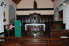
The Parish Church of Saint-Étienne (15th century) is registered as an historical monument.