
Area 9.33 km² | Canton Arthez-de-Béarn Time zone CET (UTC+1) Population 711 (1999) | |
 | ||
Argagnon (Arganhon in Occitan) is a French commune in the Pyrénées-Atlantiques department in the Nouvelle-Aquitaine region of south-western France.
Contents
- Map of 64300 Argagnon France
- Geography
- Toponymy
- History
- Administration
- Inter communality
- Demography
- Economy
- Nickname and saying
- Civil heritage
- Religious heritage
- Facilities
- Notable people linked to the commune
- References
Map of 64300 Argagnon, France
The inhabitants of the commune are known as Argagnonais or Argagnonaises
Geography
Argagnon is located some 7 km south-east of Orthez and 2 km north-west of Maslacq. Access to the commune is by the D817 road from Orthez which passes through the village and continues south-east to Artix. The D275 from Maslacq to Arthez-de-Béarn passes through the eastern part of the commune. The Toulouse-Bayonne railway passes through the south of the commune parallel to the D817 but there is no station in the commune. The nearest stations are at Orthez to the north-west and Lacq to the south-east. The commune consists mostly of farmland however there are forests in the east and north of the commune.
The commune lies in the Drainage basin of the Adour and the Gave de Pau flows through the south-western edge of the commune with the Ruisseau de Clamonde flowing into it from the commune. Paul Raymond mentioned in 1863 that the Juren, a stream with its source in Arthez-de-Béarn, crossed Aragnon and flowed into the Gave de Pau
Toponymy
Its name in Béarnais is Arganhon. Brigitte Jobbé-Duval indicated that the name Argagnon originated from the first owner, Arcanius, and was expanded with the suffix -onem giving the meaning "Domain of Arcanius".
The following table details the origins of the commune name and other names in the commune.
Sources:
Origins:
History
In 1385 Argagnon and Marcerin depended on the bailiwick of Pau. Argagnon at that time had 9 fires and Marcerin had 12.
The Lords of Argagnon were the Castera family
Argagnon until 1846 was part of the Canton of Lagor. The commune merged with Marcerin on 8 April 1851 to form the commune of Argagnon-Marcerin.
During the German occupation from 1940-1944 it was one of the official check points for the Demarcation line.
Administration
List of Successive Mayors
(Not all data is known)
Georges Vandesande sponsored the candidacy of Jacques Cheminade in the presidential election of 1995.
Inter-communality
Argagnon belongs to five inter-communal structures:
Demography
In 2009 the commune had 730 inhabitants. The evolution of the number of inhabitants is known from the population censuses conducted in the commune since 1793. From the 21st century, a census of communes with fewer than 10,000 inhabitants is held every five years, unlike larger towns that have a sample survey every year.
Sources : Ldh/EHESS/Cassini until 1962, INSEE database from 1968 (population without double counting and municipal population from 2006)
Economy
The town is part of the Appellation d'origine contrôlée (AOC) zone designation of Ossau-iraty.
Nickname and saying
According to Hubert Dutech, the inhabitants of Marcerin were called perautucs, meaning "fools". He also cited the saying A Marcerin, n'i a glèisa ni mouli, mes que i a ua houratèra, oun lou diable apèra, which means "In Marcerin there is neither church nor mill, but there is a small cave where the devil calls".
Civil heritage
Several Prehistoric camps have been found in the commune, reflecting its ancient past. The most important of them is the Turoû de Dous Garos at 90 metres altitude. Ditches surround it and there are three earthen ramparts. Remains from the Iron Age have been discovered. The park of the current chateau is located in the former castéra.
Religious heritage
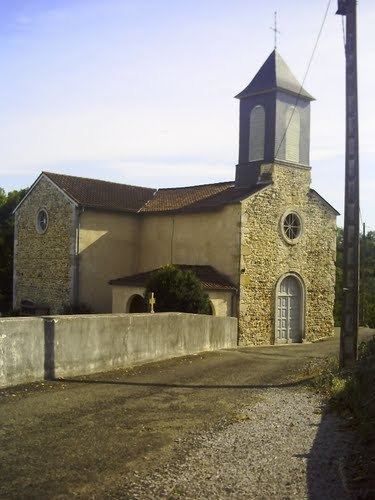
The Church of Saint-Pierre (11th century) is registered as an historical monument. It was built in 1866 on remains from the 11th century.
Facilities
Argagnon has a primary school.