Area 9,682 km² | UBIGEO 0401 Founded 1540 | |
 | ||
Website www.muniarequipa.gob.pe Clubs and Teams FBC Melgar, Sportivo Huracán, FBC Aurora, Atlético Universidad, FBC Piérola, FBC White Star, Senati FBC Points of interest Santa Catalina Monastery, Casa del Moral, Basilica Cathedral of Arequipa, Goyeneche Palace - Arequipa, Plaza de Armas Arequipa Colleges and Universities National University of Saint A, Catholic University of Santa, Universidad Católica de San Pablo, Institución Educativa Emblemá | ||
Arequipa is a province in the Arequipa Region, Peru. Its capital, Arequipa, is Peru's third most populous province of Peru. It borders the provinces of Islay, Camaná, Caylloma, and the Cusco and Puno regions. According to INEI in the year 2014 it has a population of 958.351 people.
Contents
Map of Arequipa, Peru
Geography
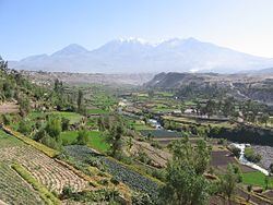
Some of the highest peaks of the province are Chachani, the Misti volcano and Pikchu Pikchu. Other mountains are listed below:
Political division
The province is divided into twenty-nine districts (Spanish: distritos, singular: distrito).
Ethnic groups
The province is inhabited by indigenous citizens of Aymara and Quechua descent. Spanish, however, is the language which the majority of the population (85.67%) learnt to speak in childhood, 1.64% of the residents started speaking using the Aymara language and 12.35% using Quechua (2007 Peru Census).
