
Population 2,058 {2011} Civil parish Ardleigh Local time Tuesday 5:00 PM District Tendring | OS grid reference TM052295 Sovereign state United Kingdom Dialling code 01206 | |
 | ||
Weather 3°C, Wind SW at 21 km/h, 84% Humidity | ||
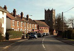
Ardleigh /ˈɑːrdli/ is a village and civil parish in Essex, England. It is situated approximately 4 miles (6 km) northeast from the centre of Colchester and 26 miles (42 km) northeast from the county town of Chelmsford.
Contents
Map of Ardleigh, UK
Ardleigh is in the district of Tendring and the parliamentary constituency of Harwich and North Essex. The village has its own Parish Council. The parish had a population of 2081 according to the 2001 census and includes the area known as Crockleford Heath.
The Great Eastern Main Line passes close to the village but the railway station closed in November 1967. The closest railway station is now at Manningtree, 3 miles (5 km) northeast. The village is on the A137 road, a route from Colchester to Ipswich, Suffolk.
Ardleigh Reservoir is less than 1 mile (1.6 km) to the southwest.
The area includes a number of smallholdings founded by the Land Settlement Association.
Governance
Ardleigh is part of the electoral ward called Ardleigh and Little Bromley. The population of this ward at the 2011 Census was 2,311.