
Municipality Kalayaan, Palawan District Truong Sa, Khanh Hoa | ||
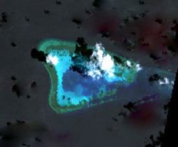 | ||
Ardasier Reef (7°37′19″N 113°51′39″E), also known as Guangxingzai Jiao (Chinese: 光星仔礁) in China, Terumbu Ubi in Malaysia, Antonio Luna in the Philippines and đá Kiệu Ngựa in Vietnam, is a triangular shaped feature on the SW extremity of Dangerous Ground in the Spratly Islands.
Map of Ardasier Reef
It lies 26km NNE of Swallow Reef, and 9km east of Dallas Reef, with the large Ardasier Bank extending 69 km ENE. Ardasier Bank, a sunken atoll except for drying Ardasier Reef at its southwestern end, has a total area of 2347 km², and its former lagoon is up to 65 metres deep.
Ardasier Reef is steep-to, except on its eastern side where it adjoins the Ardasier Bank. Its huge areas of sandy patches have an abundance of shy Guitar Sharks, Eagle Rays, Giant Reef Rays and other intriguing bottom dwelling creatures that bury themselves in the sand.
The Royal Malaysian Navy has maintained a naval station on the reef, called "Uniform Station", since 1986.