
Country Greece Postal codes 22x xx ISO 3166 code GR-12 Area 4,419 km² Population 86,820 (2011) | Region Peloponnese Area codes 2710, 275x0, 279x0 Car plates ΤΡ Capital Tripoli University University of Peloponnese | |
 | ||
Clubs and Teams Asteras Tripoli F.C., Arkadikos B.C. Points of interest Lousios, Archaeological Museum of Astros, Buffalo City Stadium, Water Power Museum, Υπαίθριο Μουσείο Υδροκίνησης Destinations Tripoli, Dimitsana, Leonidio, Megalopolis, Paralio Astros | ||
Explore greece arcadia
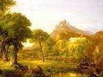
Arcadia (Greek: Αρκαδία, Arkadía) is one of the regional units of Greece. It is part of the administrative region of Peloponnese. It is situated in the central and eastern part of the Peloponnese peninsula. It takes its name from the mythological character Arcas. In Greek mythology, it was the home of the god Pan. In European Renaissance arts, Arcadia was celebrated as an unspoiled, harmonious wilderness.
Contents
- Explore greece arcadia
- Map of Arcadia Greece
- Parnon mountains laconia arcadia peloponnese greece hd travel channel
- Geography
- Medieval history
- Modern history
- Language
- Administration
- Prefecture
- Provinces
- Ancient and modern towns and cities
- Economy
- Transportation
- News
- Television
- Sports teams
- Mythology
- Ancient Arcadians
- Ancient Olympic victors
- Greek War of Independence fighters
- Politicians
- Poets
- Scientists scholars educators academicians
- Artists
- Athletes
- Other notable personalities
- References
Map of Arcadia, Greece
Parnon mountains laconia arcadia peloponnese greece hd travel channel
Geography
Arcadia has its present-day capital at Tripoli. It covers about 18% of the Peloponnese peninsula, making it the largest regional unit on the peninsula. Arcadia has a ski resort on Mount Mainalo, located about 20 km NW of Tripoli. Other mountains of Arcadia are the Parnon in the southeast and the Lykaion in the west.
The climate consists of hot summers and mild winters in the eastern part, the southern part, the low-lying areas and the central area at altitudes lower than 1,000 m. The area primarily receives rain during fall and winter months in the rest of Arcadia. Winter snow occurs commonly in the mountainous areas for much of the west and the northern part, the Taygetus area, the Mainalon.
Medieval history
After the collapse of the Roman power in the west, Arcadia became part of the Greek-speaking Byzantine Empire. Arcadia remained a beautiful, secluded area, and its inhabitants became proverbial as herdsmen leading simple pastoral unsophisticated yet happy lives, to the point that Arcadia may refer to some imaginary idyllic paradise, immortalized by Virgil's Eclogues, and later by Jacopo Sannazaro in his pastoral masterpiece, Arcadia (1504); see also Arcadia (utopia).
After the Fourth Crusade, the area became a part of the Principality of Achaea, but was progressively recovered by the Byzantine Greeks of the Despotate of the Morea from the 1260s on, a process that lasted until the mid-14th century. The region fell into the hands of the Ottoman Turks in 1460. With the exception of a period of Venetian rule in 1687–1715, the region remained under Turkish control until 1821.
The Latin phrase Et in Arcadia ego, which is usually interpreted to mean "Even in Arcadia there am I", is an example of memento mori, a cautionary reminder of the transitory nature of life and the inevitability of death. The phrase is most often associated with a 1647 painting by Nicolas Poussin, also known as "The Arcadian Shepherds". In the painting the phrase appears as an inscription on a tomb discovered by youthful figures in classical garb.
Modern history
Arcadia was one of the centres of the Greek War of Independence which saw victories in their battles including one in Tripoli. After a victorious revolutionary war, Arcadia was finally incorporated into the newly created Greek state. Arcadia saw economic growth and small emigration.
In the 20th century, Arcadia experienced extensive population loss through emigration, mostly to the Americas. Many Arcadian villages lost half their inhabitants, and fears arose that they would turn into ghost towns. Arcadia now has a smaller population than Corinthia. Demographers expected that its population would halve between 1951 and the early 21st century. The population has fallen to 87,000 in 2011.
An earthquake measuring 5.9 on the Richter magnitude scale shook Megalopoli and the surrounding area in 1965. Large numbers of buildings were destroyed, leaving people homeless. Within a couple of years, the buildings were rebuilt anti-seismically. In 1967, construction began on the Megalopoli Power Plant, which began operating in 1970, producing additional electricity for southern Greece. A mining area south of the plant is the largest mining area in the peninsula and continues to the present day with one settlement moved.
In July and August 2007 forest fires caused damage in Arcadia, notably in the mountains.
In 2008, a theory proposed by classicist Christos Mergoupis suggested that the mummified remains of Alexander the Great (not his actual tomb), may in fact be located in Gortynia-Arkadia, in the Peloponnese of Greece. Since 2008, this research is ongoing and currently being conducted in Greece. The research was first mentioned on CNN International in May 2008.
Language
When, during the Greek Dark Ages (c. 1200 BC–800 BC), Doric Greek dialects were introduced to the Peloponnese, the older language apparently survived in Arcadia, and formed part of the Arcado-Cypriot group of Greek languages. Arcadocypriot never became a literary dialect, but it is known from inscriptions. Tsan is a letter of the Greek alphabet occurring only in Arcadia, shaped like Cyrillic И; it represents an affricate that developed from labiovelars in context where they became t in other dialects.
Tsakonian Greek, still spoken on the coast of modern Arcadia (but in the Classical period considered the southern Argolid coast immediately adjoining Arcadia), is a descendant of Doric Greek, and as such is an extraordinary example of a surviving regional dialect of archaic Greek. The principal cities of Tsakonia are the Arcadian coastal towns of Leonidio and Tyros.
Administration
The regional unit Arcadia is subdivided into 5 municipalities. These are (number as in the map in the infobox):
Prefecture
As a part of the 2011 Kallikratis government reform, the regional unit Arcadia was created out of the former prefecture Arcadia (Greek: Νομός Αρκαδίας). The prefecture had the same territory as the present regional unit. At the same time, the municipalities were reorganised, according to the table below.
Provinces
Arcadia was divided into four provinces:
Note: Provinces no longer hold any legal status in Greece.
Ancient and modern towns and cities
The main towns in modern Arcadia are Tripoli, Astros, Vytina, Dimitsana, Lagkadia, Tyros, Leonidio, Levidi, Megalopolis and Stemnitsa.
Ancient cities include Acacesium (founded by Acacus), Asea, Astros, Athinaio, Daseae, Falaisia (Phalesia), Gortys, Hypsus (Stemnitsa), Heraia, Lusi, Lykaio, Lycosura, Mantineia, Megalopoli, Orchomenus (Orchomenos), Tegea, Thoknia, Trapezus, Trikolonoi, Tropaia, Tripoli, Tyros, other cities includes Basilis, Caphyae, Charisia, Ellison, Enispe, Kaous, Karyes, Methydrio, Melangeia, Oryx, Paroria, Pelagos, Rhipe, Stratia, Teuthis and several more. Cities which once belonged in Arcadia include Alea (now in Argolis) and Amilos (now in Achaia).
Economy
A thermoelectric power station which produces electricity for most of southern Greece, operates to the south of Megalopolis, along with a coal mine.
In agriculture, potato farms (dominant in central and northcentral Arcadia), mixed farming, olive groves, and pasture dominate the plains of Arcadia, especially in the area around Megalopolis and between Tripoli and Levidi.
Transportation
The Moreas Motorway (A7, E65) highway connects Tripoli with Corinth and Athens. It is being extended further southwest to Megalopoli and Kalamata.
Arcadia has two tunnels. The Artemisio Tunnel opened first, followed by the tunnel east of Megalopolis; both serve traffic flowing between Messenia and Athens.