
Department Ain Area 17.47 km² | Canton Pont-de-Vaux Population (2010) 399 Local time Tuesday 7:27 AM | |
 | ||
Weather 6°C, Wind S at 16 km/h, 79% Humidity | ||
Arbigny is a French commune in the Ain department in the Auvergne-Rhône-Alpes region of eastern France.
Contents
- Map of 01190 Arbigny France
- Vol libre arbigny 2
- Geography
- History
- Administration
- Demography
- Sites and monuments
- Protected natural areas
- References
Map of 01190 Arbigny, France
The inhabitants of the commune are known as Arbignerons or Arbigneronnes
Vol libre arbigny 2
Geography
Arbigny is some 20 km north of Mâcon and 40 km south by south-east of Chalon-sur-Saône. The commune can be accessed by the D933 from Sermoyer in the north passing through the centre of the commune and village and continuing south to Pont-de-Vaux. The D126 runs west from the village changing to the D163 at the border of the commune and continuing to Uchizy. There are two other hamlets in the commune - La Croix and La Varenne. About 80% of the commune is farmland with the rest being the forested eastern part.
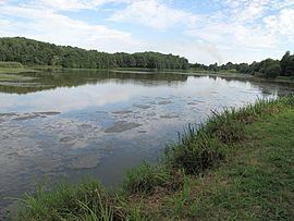
The western border of the commune is formed by the Saône river. In the north and east there are ponds which are drained by the Biel d'Etang Neuf and the Biel d'Etang Butière which flow west to the Saône.
History
The area has been occupied since prehistoric times. The village was known as Albiniacus in the Middle Ages.
Administration
List of mayors of Arbigny
(Not all data is known)
Demography
In 2010 the commune had 399 inhabitants. The evolution of the number of inhabitants is known through the population censuses conducted in the town since 1793. From the 21st century, a census of municipalities with fewer than 10,000 inhabitants is held every five years, unlike larger towns that have a sample survey every year.
Sources : Ldh/EHESS/Cassini until 1962, INSEE database from 1968 (population without double counting and municipal population from 2006)
Sites and monuments
Protected natural areas
The floodplains of the Saône Valley have been classified as protected areas since 1994.