
Country IranAzerbaijan Status Operational Length 1,026 m (3,366 ft) Height 40 m | Opening date 1971 Width (crest) 8 m (26 ft) Opened 28 June 1971 Construction began 1964 | |
 | ||
Similar Jiroft Dam, Rais Ali Dilavari Dam, Mahabad Dam, Yazd Solar Power Station, Siah Bishe Pumped Storage P | ||
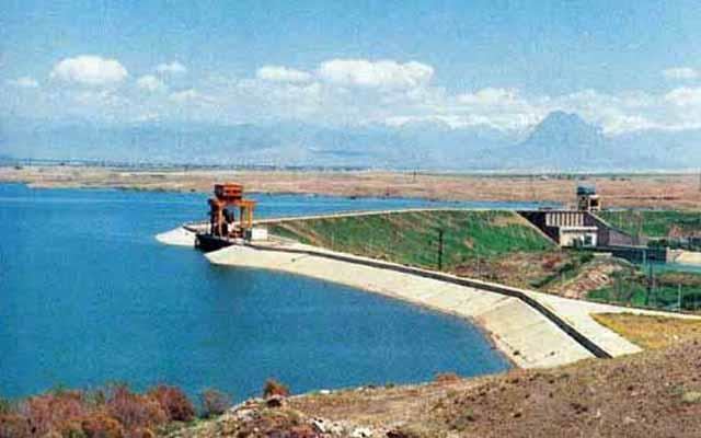
The Aras Dam (Azerbaijani: Araz su anbarı) (Persian: سَدِّ اَرَس) is an embankment dam on the Aras River along the border of Iran and Azerbaijan. It is located downstream of Poldasht in West Azerbaijan Province, Iran and Nakhchivan City in Nakhchivan Autonomous Republic, Azerbaijan. The primary purpose of the dam is hydroelectric power production and water supply.
Contents
Map of %D8%B3%D8%AF %D8%A7%D8%B1%D8%B3, Iran%E2%80%AD
HistoryEdit
On 11 August 1957, a protocol was signed between the Soviet Union and Iran in Tehran to construct the Aras Dam on the Aras River. This was done at a time when Azerbaijan was under Soviet control. Construction on the dam began in 1963 and it was completed in 1970. The dam was officially inaugurated on 28 June 1971 by Iranian deputy prime minister Safi Asfia and the Deputy Chairman of the Soviet Council of Ministers Mikhail Yefremov.
A supplementary protocol to the border agreement of 1954 between Iran and the Soviet Union was signed on 7 May 1970 in Moscow to redelimit the border along the Aras reservoir.
DamEdit
The Aras Dam is 40 metres (130 ft) tall from its foundation and 34 metres (112 ft) tall from the riverbed. It is an embankment type with sand fill and a clay core. It is 1,026 metres (3,366 ft) long and 8 metres (26 ft) wide on its crest.
ReservoirEdit
The Araz reservoir (Azerbaijani: Araz su anbarı), also known as Araz Water Junction (Azerbaijani: Araz Su Qovsağı) is a large reservoir created by the Aras Dam and shared by Nakhchivan exclave of Azerbaijan Republic and Iran.
At a normal water elevation of 777.5 metres (2,551 ft) above sea level, the dam withholds a reservoir of 1.35 cubic kilometres (1,090,000 acre·ft) with a surface area of 145 square kilometres (56 sq mi).<arasd/> Of the reservoir's normal capacity, 1.15 cubic kilometres (930,000 acre·ft) of it is active or "useful" while 0.2 cubic kilometres (160,000 acre·ft) is inactive or dead storage. The maximum storage of the reservoir is 1.75 cubic kilometres (1,420,000 acre·ft). The reservoir is 52 kilometres (32 mi) long and 6.1 kilometres (3.8 mi) wide. The average depth at normal water levels is 18.2 metres (60 ft).
There are a total of four hydro-electric stations in Azerbaijan and Iran (two on each side) with four turbines. The discharge capacity of one spillway of a station is 66.5 m3/s (2,350 cu ft/s).
Since opening, the reservoir has provided irrigation water for 400,000 hectares (990,000 acres) of arable land in Azerbaijan and Iran, including about 60,000 hectares (150,000 acres) in Dasht-e Moghan area.
Power stationEdit
The dam's power station contains four turbine-generators for a capacity of 11 megawatts (15,000 hp) each. Two of the generators are on the Iranian side and the other two on the Azerbaijani side along with the dam's spillway. The discharge capacity of one spillway of a station is 66.5 cubic metres per second (2,350 cu ft/s). The total installed capacity is 44 MW.